Category:Cruggleton Church
Jump to navigation
Jump to search
| Object location | | View all coordinates using: OpenStreetMap |
|---|
|
This is a category about listed building number 16875. |
|
This is a category about scheduled monument number 2006
|
church building and graveyard in Dumfries and Galloway, Scotland, UK .jpg) | |||||
| Upload media | |||||
| Instance of | |||||
|---|---|---|---|---|---|
| Location |
| ||||
| Heritage designation |
| ||||
 | |||||
Media in category "Cruggleton Church"
The following 25 files are in this category, out of 25 total.
-
 2016.09.09 5-Cruggleton Church (7A).jpg 3,648 × 2,736; 2.25 MB
-

-
 Approaching the remains of Cruggleton Castle - geograph.org.uk - 5826584.jpg 5,184 × 3,888; 6.92 MB
-
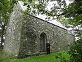
 Cruggleton Church - geograph.org.uk - 1282482.jpg 640 × 428; 58 KB
-
 Cruggleton Church - geograph.org.uk - 1282501.jpg 640 × 428; 135 KB
-
 Cruggleton Church - geograph.org.uk - 1558452.jpg 474 × 640; 138 KB
-
 Cruggleton Church - sourrounding wall - geograph.org.uk - 604377.jpg 640 × 480; 162 KB
-
 Cruggleton Church cemetery wall and entrances, Galloway.jpg 4,896 × 2,752; 3.91 MB
-
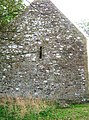
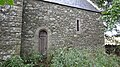
 Cruggleton church detail.JPG 1,712 × 2,288; 1.4 MB
-
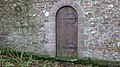
 Cruggleton Church door.JPG 1,712 × 2,288; 1.3 MB
-
 Cruggleton Church through iron gate - geograph.org.uk - 604373.jpg 480 × 640; 136 KB
-
 Cruggleton church.jpg 640 × 480; 117 KB
-
 Cruggleton churchyard.JPG 2,288 × 1,712; 1.41 MB
-
 Cruggleton Heights and the east of The Machars - geograph.org.uk - 5826652.jpg 5,100 × 3,733; 4.61 MB
-
 Cruggleton old church - geograph.org.uk - 89024.jpg 640 × 427; 113 KB
-
 Cruggleton old parish church chancel. Door and window. South facing side.jpg 4,896 × 2,752; 5.66 MB
-
 Cruggleton old parish church chancel. Door. North facing side.jpg 4,896 × 2,752; 3.89 MB
-
 Cruggleton old parish church. Enclosure and gravestone site. Galloway.jpg 4,896 × 2,752; 5.74 MB
-
 Cruggleton old parish church. South door into the nave. Galloway.jpg 4,280 × 2,601; 2.69 MB
-
 Cruggleton old parish church. Wall at enclosure and gravestone site.jpg 4,896 × 2,752; 5.24 MB
-
 Cruggleton old parish church. West end with four large boulders in a row. Galloway.jpg 4,896 × 2,752; 4.59 MB
-
 Old Cruggleton Parish Church's cemetery wall and entrance, Galloway.jpg 4,896 × 2,752; 4.26 MB
-
 Old Cruggleton Parish Church's chancel and nave wall and door, Galloway.jpg 4,896 × 2,752; 4.04 MB
-
 Old Cruggleton Parish Church's chancel end wall and window, Galloway.jpg 4,896 × 2,752; 3.09 MB
-
 The old Cruggleton Parish Church cemetery wall and entrance, Galloway.jpg 4,896 × 2,752; 2.7 MB
.jpg)


