Category:Cut banks in Taiwan
Jump to navigation
Jump to search
Limited recognition: Taiwan
中文(臺灣):臺灣的侵蝕坡(或稱「切割坡」、「攻擊坡」)
Media in category "Cut banks in Taiwan"
The following 6 files are in this category, out of 6 total.
-
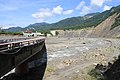
 2023 Baolai Ni.jpg 6,000 × 3,376; 11.13 MB
-
 Cingshuei River flows at the foot of Muguatan Mountain.jpg 4,000 × 3,000; 3.31 MB
-
 Landslide caused by river erosion near the Tongtou Bridge.jpg 4,000 × 3,000; 2.39 MB
-
 River cliff on the outer bank of the Cingshuei River near Binlangzhai.jpg 4,000 × 3,000; 2.48 MB
-
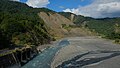
 Serious riverbank erosion is occurring along the Laonong River below Baolai No.2 Bridge.jpg 4,752 × 3,168; 6.51 MB
-
 Undercut Slope of Cingshuei River( Nantou County ).JPG 640 × 480; 38 KB


.JPG)