Category:Důl Gabriela
Jump to navigation
Jump to search
| Object location | | View all coordinates using: OpenStreetMap |
|---|
|
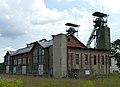
This is a category about a cultural monument of the Czech Republic,
number: 49083/8-4011. |
mine in Karviná, Czechia .JPG) | |||||
| Upload media | |||||
| Instance of | |||||
|---|---|---|---|---|---|
| Location | Doly, Karviná, Karviná District, Moravian-Silesian Region, Czechia | ||||
| Located on street |
| ||||
| Heritage designation | |||||
 | |||||
Subcategories
This category has only the following subcategory.
C
Media in category "Důl Gabriela"
The following 5 files are in this category, out of 5 total.
-
 Důl Gabriela v roce 2005.JPG 2,048 × 1,536; 514 KB
-
 Karviná, důl Gabriela (1).JPG 2,800 × 3,855; 6.36 MB
-
 Karviná, důl Gabriela (2).JPG 2,590 × 3,460; 5.08 MB
-
 Karviná, důl Gabriela (3).JPG 3,682 × 2,669; 5.07 MB
-
 V dole.jpg 2,120 × 2,018; 383 KB

.JPG)
.JPG)
