Category:Dahlwitz church
Jump to navigation
Jump to search
| Object location | | View all coordinates using: OpenStreetMap |
|---|
 | |||||
| Upload media | |||||
| Instance of | |||||
|---|---|---|---|---|---|
| Location | Dahlwitz-Hoppegarten, Hoppegarten, Märkisch-Oderland District, Brandenburg, Germany | ||||
| Heritage designation | |||||
 | |||||
This is the category of the Brandenburger Baudenkmal (cultural heritage monument) with the ID 09180388 (Wikidata)
|
English: Pictures of the church in Dahlwitz, Hoppegarten municipality, Märkisch-Oderland district, Brandenburg state, Germany
Deutsch: Bilder der Kirche in Dahlwitz, Gemeinde Hoppegarten, Landkreis Märkisch-Oderland, Land Brandenburg, Deutschland.
Français : Photos de l'église à Dahlwitz, commune de Hoppegarten, arrondissement de Märkisch-Oderland, état fédéral de Brandebourg, Allemagne
Media in category "Dahlwitz church"
The following 10 files are in this category, out of 10 total.
-
 Dahlwitz - Dorfanger (Village Green) - geo.hlipp.de - 36103.jpg 640 × 480; 121 KB
-
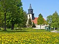
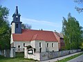 Dahlwitz - Dorfkirche (Village Church) - geo.hlipp.de - 36114.jpg 640 × 480; 69 KB
-
 Dahlwitz-Hoppegarten Rudolf-Breitscheid-Straße 34 Village Church 2.jpg 2,048 × 1,536; 985 KB
-
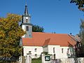
 Dorfkirche Dahlwitz 2018 ESE.jpg 4,949 × 4,677; 8.31 MB
-
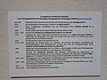 Dorfkirche Dahlwitz 2018 Infotafel.jpg 4,864 × 3,648; 4.43 MB
-
 Dorfkirche Dahlwitz 2018 S.jpg 4,073 × 4,451; 7.03 MB
-
 Dorfkirche Dahlwitz 2018 SW.jpg 4,864 × 3,648; 6.01 MB
-
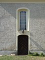 Dorfkirche Dahlwitz 2018 Südportal.jpg 3,648 × 4,864; 6.97 MB
-
 Dorfkirche Dahlwitz 2018 Turm.jpg 3,648 × 4,864; 4.46 MB
-
 Dorfkirche Dahlwitz 2018 Westportal.jpg 3,648 × 4,864; 6.1 MB
_-_geo.hlipp.de_-_36103.jpg)
_-_geo.hlipp.de_-_36114.jpg)


