Category:Dale, Pembrokeshire
Jump to navigation
Jump to search
village and community in Pembrokeshire, Wales, UK   | |||||
| Upload media | |||||
| Instance of | |||||
|---|---|---|---|---|---|
| Located in protected area | |||||
| Location | Pembrokeshire, Wales | ||||
| Population |
| ||||
 | |||||
Cymraeg: Pentref ar arfordir Sir Benfro yw Dale, i'r gogledd-orllewin o Aberdaugleddau. Saif yn y rhan Saesneg o Sir Benfro, ac nid ymddengys fod enw Cymraeg iddo. Daw'r enw "Dale" o'r Hen Norwyeg Dalr ("dyffryn"). Gerllaw mae Llwybr Arfordir Sir Benfro.
English: Dale is a small village and civil parish in Pembrokeshire, West Wales, located on the Dale Peninsula which forms the northern side of the entrance to Milford Haven estuary.
Subcategories
This category has the following 6 subcategories, out of 6 total.
Media in category "Dale, Pembrokeshire"
The following 200 files are in this category, out of 374 total.
(previous page) (next page)-
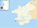 2010 Wales Pembrokeshire Community Dale map.svg 512 × 393; 1,018 KB
-
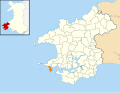 2024 Wales Pembrokeshire Community Dale map.svg 512 × 393; 1.19 MB
-
 A backward glance - geograph.org.uk - 6193627.jpg 2,048 × 1,536; 855 KB
-
 A Cottage Near St Anne's Head - geograph.org.uk - 4533560.jpg 1,600 × 1,067; 454 KB
-
 A curious walled area on St Ann's Head - geograph.org.uk - 1526253.jpg 640 × 480; 235 KB
-
 A hazy St. Ann's Head lighthouse from Angle - geograph.org.uk - 5427286.jpg 1,024 × 768; 124 KB
-
 A precarious footpath leads to a WW2 searchlight housing - geograph.org.uk - 4071693.jpg 2,346 × 3,128; 2.49 MB
-

-

-
 Access track to former RNAS Kete - geograph.org.uk - 4072060.jpg 2,346 × 3,128; 1.81 MB
-
 Across Castlebeach Bay - geograph.org.uk - 3761238.jpg 3,077 × 2,124; 971 KB
-
 Across the lake - geograph.org.uk - 6193458.jpg 1,536 × 2,048; 1.03 MB
-
 Advancing tide at Westdale Bay - geograph.org.uk - 3762645.jpg 3,940 × 2,593; 1.26 MB
-

-
 Atlantic surf, Westdale Bay - geograph.org.uk - 3762640.jpg 4,265 × 2,116; 935 KB
-
 B4327 near Dale - geograph.org.uk - 4402417.jpg 640 × 480; 160 KB
-
 Bales of hay - geograph.org.uk - 6197919.jpg 2,048 × 1,536; 1.21 MB
-
 Beach at Dale - geograph.org.uk - 5895246.jpg 1,600 × 1,200; 379 KB
-
 Beach at Pickleridge, near Dale, Pembrokeshire, Wales.jpg 3,000 × 4,000; 5.07 MB
-
 Beach near Dale - geograph.org.uk - 3555532.jpg 640 × 480; 88 KB
-

-
 Black Rock At Dale - geograph.org.uk - 4533703.jpg 640 × 455; 43 KB
-
 Blowing in the wind - geograph.org.uk - 6197934.jpg 2,048 × 1,536; 1.42 MB
-
 Boat Trips Out of Dale - geograph.org.uk - 4533685.jpg 1,600 × 870; 168 KB
-
 Boats at Dale - geograph.org.uk - 3555545.jpg 640 × 480; 92 KB
-
 Boats at Dale in the evening - geograph.org.uk - 2594407.jpg 4,032 × 3,024; 1.47 MB
-
 Boats at Dale in the evening - geograph.org.uk - 2594452.jpg 4,032 × 3,024; 1.29 MB
-

-
 Caer Oes Haearn Dale Iron Age Fort - geograph.org.uk - 2683822.jpg 640 × 480; 97 KB
-
 Calm Rock-it says on the map-not sure I agree - geograph.org.uk - 4071721.jpg 3,128 × 2,346; 1.9 MB
-
 Car park - geograph.org.uk - 3555538.jpg 640 × 480; 77 KB
-
 Castell Dale - Dale Castle - geograph.org.uk - 4438046.jpg 640 × 480; 107 KB
-
 Castle Beach - geograph.org.uk - 6197905.jpg 1,536 × 2,048; 1.15 MB
-
 Castlebeach Bay - geograph.org.uk - 3163105.jpg 640 × 480; 90 KB
-
 Castlebeach Bay - geograph.org.uk - 3761234.jpg 4,320 × 3,240; 2.51 MB
-
 Castlebeach Bay - geograph.org.uk - 6197921.jpg 3,088 × 2,314; 2.25 MB
-
 Castlebeach Bay and Dale Fort - geograph.org.uk - 3163115.jpg 640 × 480; 66 KB
-
 Castlebeach Bay looking out over Milford Haven - geograph.org.uk - 4071860.jpg 3,128 × 2,346; 1.48 MB
-
 Castlebeach Bay, Pembrokeshire - geograph.org.uk - 1841627.jpg 640 × 480; 85 KB
-
 Castlebeach Footbridge - geograph.org.uk - 4216791.jpg 1,333 × 2,000; 612 KB
-

-
 Chainsaw carvings - geograph.org.uk - 3163092.jpg 640 × 480; 90 KB
-
 Cliff Scenery - geograph.org.uk - 4176518.jpg 1,024 × 768; 438 KB
-
 Cliff View - geograph.org.uk - 161286.jpg 640 × 490; 394 KB
-
 Cliffs at St Ann's Head - geograph.org.uk - 415568.jpg 640 × 480; 77 KB
-
 Cliffs, Dale - geograph.org.uk - 5205035.jpg 2,000 × 1,470; 987 KB
-
 Coast Path along the Field Edge - geograph.org.uk - 4175174.jpg 1,024 × 768; 440 KB
-
 Coast path at Pickleridge - geograph.org.uk - 6193452.jpg 1,536 × 2,048; 1.23 MB
-
 Coastal defence battery at West Blockhouse - geograph.org.uk - 4072019.jpg 3,128 × 2,346; 1.98 MB
-
 Coastal defence battery circa 1900 - geograph.org.uk - 4073117.jpg 3,128 × 2,346; 1.83 MB
-
 Coastal defence battery circa 1900 - geograph.org.uk - 4073122.jpg 2,346 × 3,128; 1.92 MB
-
 Coastal scene, Dale - geograph.org.uk - 5204974.jpg 2,000 × 1,500; 993 KB
-
 Coastguard Cottages, St Ann's Head - geograph.org.uk - 5895243.jpg 1,600 × 1,170; 346 KB
-
 Coastguard HQ, lookout and lighthouse on St Ann's Head - geograph.org.uk - 3123264.jpg 4,000 × 3,000; 2.91 MB
-
 Commemorative plaque - geograph.org.uk - 6199115.jpg 2,048 × 1,536; 1.54 MB
-
 Commemorative stone - geograph.org.uk - 6199110.jpg 1,536 × 2,048; 1.44 MB
-
 Cow parsley - geograph.org.uk - 6197946.jpg 3,165 × 2,374; 2.69 MB
-
 Cows grazing at St Ann's Head - geograph.org.uk - 6257277.jpg 640 × 480; 43 KB
-
 Dale - A Fishing Trip Into The Unknown^ - geograph.org.uk - 4533578.jpg 1,600 × 1,030; 231 KB
-
 Dale - geograph.org.uk - 126959.jpg 640 × 439; 97 KB
-
 Dale - geograph.org.uk - 2035973.jpg 1,280 × 856; 236 KB
-
 Dale - geograph.org.uk - 2035990.jpg 1,280 × 856; 239 KB
-
 Dale - geograph.org.uk - 4486220.jpg 640 × 430; 54 KB
-
 Dale - geograph.org.uk - 4876878.jpg 2,576 × 1,932; 1.3 MB
-
 Dale - geograph.org.uk - 4876881.jpg 2,576 × 1,932; 1.27 MB
-
 Dale - geograph.org.uk - 4876884.jpg 2,576 × 1,932; 1.29 MB
-
 Dale - geograph.org.uk - 4876888.jpg 2,576 × 1,932; 1.26 MB
-
 Dale - geograph.org.uk - 4876896.jpg 2,576 × 1,932; 1.26 MB
-
 Dale - geograph.org.uk - 4876923.jpg 2,036 × 1,528; 676 KB
-
 Dale - lime kiln - geograph.org.uk - 4876899.jpg 2,576 × 1,932; 1.22 MB
-
 Dale - lime kiln - geograph.org.uk - 4876908.jpg 2,576 × 1,932; 1.22 MB
-
 Dale - lime kiln - geograph.org.uk - 4876912.jpg 2,576 × 1,932; 1.24 MB
-
 Dale - lime kiln - geograph.org.uk - 4876917.jpg 2,576 × 1,932; 1.26 MB
-
 Dale - lime kiln - geograph.org.uk - 4876922.jpg 2,576 × 1,932; 1.07 MB
-
 Dale - lime kiln - information board - geograph.org.uk - 4876902.jpg 2,576 × 1,932; 1.23 MB
-
 Dale - lime kiln - information board - geograph.org.uk - 4876905.jpg 2,576 × 1,932; 1.26 MB
-
 Dale - panoramio (1).jpg 3,072 × 2,304; 2.76 MB
-
 Dale - panoramio.jpg 3,072 × 2,304; 2.65 MB
-
 Dale - Pembrokeshire. - geograph.org.uk - 93575.jpg 640 × 423; 70 KB
-
 Dale 1971 - geograph.org.uk - 2805219.jpg 640 × 430; 124 KB
-
 Dale airfield (disused) - geograph.org.uk - 1517109.jpg 640 × 480; 64 KB
-
 Dale airfield - geograph.org.uk - 6193637.jpg 2,048 × 1,536; 907 KB
-

-
 Dale Beach - geograph.org.uk - 2035977.jpg 1,280 × 856; 269 KB
-
 Dale Beach - geograph.org.uk - 2035979.jpg 856 × 1,280; 264 KB
-
 Dale beach - geograph.org.uk - 4815502.jpg 3,810 × 2,494; 4.02 MB
-
 Dale Beach - geograph.org.uk - 5804596.jpg 1,280 × 960; 458 KB
-
 Dale beach, Rockpools - geograph.org.uk - 4815519.jpg 2,512 × 2,493; 2.47 MB
-
 Dale Castle (geograph 6199239).jpg 2,048 × 1,536; 1.16 MB
-
 Dale Castle - geograph.org.uk - 3761226.jpg 4,320 × 3,240; 2.36 MB
-
 Dale Castle - geograph.org.uk - 4583539.jpg 1,024 × 768; 153 KB
-
 Dale Castle - geograph.org.uk - 5205255.jpg 2,000 × 1,500; 981 KB
-
 Dale Castle - geograph.org.uk - 6193526.jpg 2,951 × 2,120; 1.12 MB
-
 Dale Castle - geograph.org.uk - 6199249.jpg 2,048 × 1,536; 801 KB
-
 Dale Castle and Church. - geograph.org.uk - 142680.jpg 640 × 481; 318 KB
-

-
 Dale Castle farm - geograph.org.uk - 1524923.jpg 640 × 480; 193 KB
-
 Dale Castle Farm - geograph.org.uk - 784474.jpg 640 × 480; 72 KB
-
 Dale Castle From The Coast Path - geograph.org.uk - 4533501.jpg 1,600 × 888; 268 KB
-
 Dale Castle IMG 1981c-Edit.jpg 1,500 × 996; 194 KB
-
 Dale Castle.jpg 2,560 × 1,920; 3.42 MB
-
 Dale cemetery - geograph.org.uk - 1524918.jpg 640 × 480; 219 KB
-
 Dale Fort - geograph.org.uk - 3163121.jpg 640 × 480; 89 KB
-
 Dale Fort - geograph.org.uk - 5205304.jpg 1,980 × 1,296; 648 KB
-
 Dale Habour.jpg 2,560 × 1,920; 3.2 MB
-
 Dale Lime Kilns - geograph.org.uk - 5289697.jpg 2,031 × 1,005; 410 KB
-
 Dale Mill.jpg 480 × 640; 70 KB
-
 Dale on a windy August lunchtime - geograph.org.uk - 6279617.jpg 640 × 480; 35 KB
-
 Dale Point and Fort - geograph.org.uk - 1495904.jpg 640 × 480; 89 KB
-
 Dale Point and fort - geograph.org.uk - 1526296.jpg 640 × 480; 179 KB
-
 Dale Roads - geograph.org.uk - 1841635.jpg 640 × 480; 103 KB
-
 Dale Roads - geograph.org.uk - 4276009.jpg 640 × 480; 37 KB
-
 Dale Roads - geograph.org.uk - 4276010.jpg 640 × 480; 38 KB
-
 Dale Roads - geograph.org.uk - 6193510.jpg 2,048 × 1,536; 1 MB
-
 Dale Roads - geograph.org.uk - 6195323.jpg 2,048 × 1,536; 457 KB
-
 Dale Roads - geograph.org.uk - 6197899.jpg 2,048 × 1,536; 1.33 MB
-
 Dale Roads and Village - geograph.org.uk - 1590882.jpg 640 × 425; 57 KB
-
 Dale Roads Bay - geograph.org.uk - 161344.jpg 640 × 335; 217 KB
-
 Dale St Anns Head - panoramio.jpg 2,048 × 1,536; 847 KB
-
 Dale, Attractive seaside cottages - geograph.org.uk - 4815516.jpg 3,872 × 2,592; 5.23 MB
-
 Dale, Pembrokeshire - geograph.org.uk - 1023740.jpg 640 × 480; 113 KB
-
 Dale, Pembrokeshire - geograph.org.uk - 87970.jpg 640 × 480; 184 KB
-
 Dale, Pembrokeshire.jpg 1,782 × 1,272; 1.01 MB
-
 Deep clefts on St. Ann's Head - geograph.org.uk - 1841596.jpg 640 × 480; 73 KB
-
 Dinghies by the Roadside - geograph.org.uk - 4175123.jpg 1,024 × 768; 364 KB
-
 Dispersal area on the edge of Dale airfield - geograph.org.uk - 4073053.jpg 3,128 × 2,346; 1.35 MB
-
-
 Domestic quarters on the NW corner of Dale airfield - geograph.org.uk - 4073038.jpg 3,128 × 2,346; 1.36 MB
-
 Down towards Mill Bay - geograph.org.uk - 2036010.jpg 1,280 × 856; 201 KB
-
 Dusk at Westdale Bay, Pembrokeshire - geograph.org.uk - 5025852.jpg 4,608 × 3,456; 3.68 MB
-
 Eastward up Milford Haven from Dale Road, 1994 - geograph.org.uk - 4746099.jpg 2,423 × 1,326; 2.97 MB
-
 Evening at Frenchman's Bay, St Ann's Head - geograph.org.uk - 6462301.jpg 1,799 × 1,199; 456 KB
-
 Fenced pasture - geograph.org.uk - 6194175.jpg 3,264 × 2,448; 2.67 MB
-
 Floating pontoon and beach at Dale - geograph.org.uk - 2927319.jpg 3,008 × 2,000; 1.21 MB
-
 Floating pontoon at Dale - geograph.org.uk - 3163089.jpg 640 × 480; 114 KB
-
 Folded Old Red Sandstone at Cobbler's Hole - geograph.org.uk - 4176507.jpg 1,024 × 768; 457 KB
-

-

-
 Frenchman's Bay - geograph.org.uk - 5895233.jpg 1,600 × 1,179; 457 KB
-
 Gateholm Island - geograph.org.uk - 6194169.jpg 2,580 × 3,250; 2.05 MB
-
 Gateway to concrete track at Kete - geograph.org.uk - 6198577.jpg 2,048 × 1,536; 1.17 MB
-
 Ger - Near Iron Point - geograph.org.uk - 4438054.jpg 640 × 480; 102 KB
-
 Grassland on Lower Marloes Farm - geograph.org.uk - 6194699.jpg 2,048 × 1,536; 641 KB
-
 Great Castle Head - geograph.org.uk - 1524928.jpg 480 × 640; 199 KB
-
 Great Castle Head - geograph.org.uk - 3762626.jpg 4,320 × 3,240; 2.36 MB
-
 Great Castle Head - geograph.org.uk - 784484.jpg 640 × 480; 108 KB
-
 Great Castle Head Fort - geograph.org.uk - 4532419.jpg 1,600 × 1,066; 514 KB
-

-
 Grid reference plate on fence post - geograph.org.uk - 6198559.jpg 2,413 × 3,217; 2.63 MB
-
 Griffin Inn - geograph.org.uk - 3555548.jpg 640 × 480; 93 KB
-
 Griffin Inn at Dale - geograph.org.uk - 2927315.jpg 3,008 × 2,000; 1.59 MB
-
 Guinea Fowl, Dale - geograph.org.uk - 4400974.jpg 640 × 480; 219 KB
-
 Guinea Fowl, Dale - geograph.org.uk - 4400981.jpg 640 × 480; 139 KB
-
 Gun Emplacements at West Blockhouse Battery - geograph.org.uk - 4175261.jpg 1,024 × 768; 413 KB
-
 Harbour with boats, Dale - geograph.org.uk - 4044907.jpg 2,003 × 1,348; 1.17 MB
-
 Helipad, St Ann's Head - geograph.org.uk - 5895239.jpg 1,600 × 1,166; 288 KB
-
 Hen Oleudy St Anne's Old Lighthouse - geograph.org.uk - 4438072.jpg 640 × 480; 57 KB
-
 Hill fort - geograph.org.uk - 6198561.jpg 2,048 × 1,536; 1.17 MB
-
 Houses facing the beach, Dale - geograph.org.uk - 5205353.jpg 2,000 × 1,500; 961 KB
-
 Information board relating to former RNAS Kete - geograph.org.uk - 4072053.jpg 3,128 × 2,346; 1.27 MB
-
 Inside St James the Great, Dale (1) - geograph.org.uk - 6279601.jpg 640 × 480; 57 KB
-
 Inside St James the Great, Dale (2) - geograph.org.uk - 6279603.jpg 640 × 480; 38 KB
-
 Inside St James the Great, Dale (3) - geograph.org.uk - 6279604.jpg 640 × 480; 46 KB
-
 Inside St James the Great, Dale (4) - geograph.org.uk - 6279605.jpg 640 × 480; 65 KB
-
 Inside St James the Great, Dale (5) - geograph.org.uk - 6279606.jpg 480 × 640; 40 KB
-
 Inside St James the Great, Dale (6) - geograph.org.uk - 6279608.jpg 640 × 480; 52 KB
-
 Inside St James the Great, Dale (7) - geograph.org.uk - 6279610.jpg 640 × 480; 81 KB
-
 Inside St James the Great, Dale (7) - geograph.org.uk - 6279611.jpg 640 × 480; 60 KB
-
 Inside St James the Great, Dale (8) - geograph.org.uk - 6279613.jpg 640 × 480; 49 KB
-
 Iron Point - geograph.org.uk - 4176589.jpg 1,024 × 768; 447 KB
-
 Jagged rocks - geograph.org.uk - 6194067.jpg 1,536 × 2,048; 546 KB
-

-
 Kete, Dale - geograph.org.uk - 5205233.jpg 2,000 × 1,500; 812 KB
-
 Kissing gate and fence - geograph.org.uk - 6194064.jpg 2,048 × 1,536; 924 KB
-
 Ladies a Lazing Near St Anne's Lighthouse - geograph.org.uk - 4533546.jpg 1,600 × 1,067; 497 KB
-
 Lighthouse at St Ann's Head - geograph.org.uk - 4407515.jpg 640 × 480; 129 KB
-
 Lighthouse At St Anne's Head - geograph.org.uk - 4533522.jpg 1,600 × 932; 245 KB
-
 Lighthouse at St. Ann's Head - geograph.org.uk - 3709590.jpg 480 × 640; 53 KB
-
 Lime Kilns - geograph.org.uk - 161357.jpg 640 × 245; 270 KB
-
 Lime kilns - geograph.org.uk - 6195318.jpg 2,048 × 1,536; 1.28 MB
-
 Lime Kilns near Dale - geograph.org.uk - 876276.jpg 640 × 480; 85 KB
-
 Little Castle Point - geograph.org.uk - 1526178.jpg 480 × 640; 230 KB
-
 Little Castle Point - geograph.org.uk - 3762592.jpg 3,175 × 3,552; 1.75 MB
-
 Little Castle Point - geograph.org.uk - 5895229.jpg 1,600 × 1,200; 438 KB
-
 Little Castle Point - geograph.org.uk - 6198500.jpg 2,048 × 1,536; 907 KB
-
 Long Point - geograph.org.uk - 1526169.jpg 640 × 480; 230 KB
-
 Long Point - geograph.org.uk - 3762619.jpg 4,278 × 3,182; 1.86 MB
-
 Looking across the valley to Dale - geograph.org.uk - 784446.jpg 640 × 480; 110 KB
-
 Looking SSE from the B4327, 1985 - geograph.org.uk - 5306130.jpg 453 × 640; 70 KB
-
 Looking towards Milford Haven from Dale beach - geograph.org.uk - 4815510.jpg 3,792 × 2,468; 3.18 MB
-
 Looking westwards from Kete Car Park - geograph.org.uk - 6257283.jpg 640 × 480; 41 KB
-
 Low level red beacon below West Blockhouse - geograph.org.uk - 4071676.jpg 2,346 × 3,128; 2.06 MB
-
 Low tide coast path on Pickleridge - geograph.org.uk - 5205282.jpg 2,000 × 1,500; 1.1 MB
-
 Lower cliff face at Watwick Bay - geograph.org.uk - 4073148.jpg 2,346 × 3,128; 1.44 MB
-
 Lower cliff face at Watwick Bay - geograph.org.uk - 4073151.jpg 2,346 × 3,128; 1.33 MB
-
 Marloes Sands - geograph.org.uk - 6194161.jpg 3,264 × 2,448; 2.95 MB
-
 Mill Bay - geograph.org.uk - 3761415.jpg 3,240 × 4,320; 2.47 MB
-
 Mill Bay - geograph.org.uk - 4175307.jpg 1,024 × 768; 446 KB
-
 Mill Bay - geograph.org.uk - 6197986.jpg 2,048 × 1,536; 1.4 MB
-
 National Trust Car park at Kete - geograph.org.uk - 5289664.jpg 4,896 × 3,672; 5.81 MB


.jpg)


_-_geograph.org.uk_-_1517109.jpg)


.jpg)


_-_geograph.org.uk_-_6279601.jpg)
_-_geograph.org.uk_-_6279603.jpg)
_-_geograph.org.uk_-_6279604.jpg)
_-_geograph.org.uk_-_6279605.jpg)
_-_geograph.org.uk_-_6279606.jpg)
_-_geograph.org.uk_-_6279608.jpg)
_-_geograph.org.uk_-_6279610.jpg)
_-_geograph.org.uk_-_6279611.jpg)
_-_geograph.org.uk_-_6279613.jpg)


