Category:Dar al-Fadilah Mosque
Jump to navigation
Jump to search
| Object location | | View all coordinates using: OpenStreetMap |
|---|
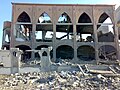
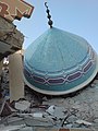
English: Mosque of the Dar al-Fadilah orphanage and school, southeast of Rafah. Opened in 2005 and destroyed in 2009 during the Gaza War.
Media in category "Dar al-Fadilah Mosque"
The following 17 files are in this category, out of 17 total.
-
 14 - Destroyed mosque.jpg 2,048 × 1,536; 807 KB
-
 15 - Destroyed mosque.jpg 2,592 × 1,944; 1.26 MB
-
 16 - Destroyed mosque (3193920571).jpg 1,632 × 1,224; 232 KB
-
 17 - Destroyed mosque (3193920857).jpg 1,224 × 1,632; 213 KB
-
 18 - Destroyed mosque.jpg 1,224 × 1,632; 159 KB
-
 19 - Destroyed mosque (3193920655).jpg 1,632 × 1,224; 215 KB
-
 20 - Destroyed mosque (3193920461).jpg 1,224 × 1,632; 187 KB
-
 21 - Destroyed mosque (3193919905).jpg 1,224 × 1,632; 181 KB
-
 23 - Destroyed mosque (3194763822).jpg 1,632 × 1,224; 257 KB
-
 24 - Destroyed mosque.jpg 1,632 × 1,224; 270 KB
-
 25 - Destroyed mosque (3194763686).jpg 1,224 × 1,632; 239 KB
-
 26 - Destroyed mosque (3194764334).jpg 1,224 × 1,632; 203 KB
-
 27 - Destroyed mosque (3193921781).jpg 2,048 × 1,536; 485 KB
-
 28 - Destroyed mosque (3194764974).jpg 2,048 × 1,536; 595 KB
-
 29 - Destroyed mosque (3193920377).jpg 1,632 × 1,224; 223 KB
-
 30 - Destroyed mosque (3194764522).jpg 1,632 × 1,224; 285 KB
-
 Cast Lead Mosque.jpg 2,048 × 1,536; 586 KB


.jpg)
.jpg)

.jpg)
.jpg)
.jpg)
.jpg)

.jpg)
.jpg)
.jpg)
.jpg)
.jpg)
.jpg)
