Category:Daver 20, Kerk-Avezaath
Jump to navigation
Jump to search
| Object location | | View all coordinates using: OpenStreetMap |
|---|
 | |||||
| Upload media | |||||
| Instance of | |||||
|---|---|---|---|---|---|
| Location | Buren, Gelderland, Netherlands | ||||
| Street address |
| ||||
| Located on street |
| ||||
| Heritage designation |
| ||||
 | |||||
Nederlands: Boerderij Kamphof
|
This is a category about rijksmonument number 11444
|
| Address |
|
Media in category "Daver 20, Kerk-Avezaath"
The following 5 files are in this category, out of 5 total.
-
 Achtergevel - Kerk Avezaath - 20512681 - RCE.jpg 1,200 × 900; 161 KB
-
 Boerderij Kamphof, vooraanzicht - Kerk-Avezaath - 20124522 - RCE.jpg 1,200 × 1,185; 370 KB
-
 Inrijhek en voor- en zijgevel - Kerk Avezaath - 20512680 - RCE.jpg 1,200 × 900; 171 KB
-
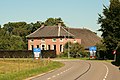 Kerk-Avezaath - Daver 20 - Boerderij "Kamphof".JPG 3,888 × 2,592; 6.74 MB
-
 Voor- en zijgevel dia 902748 - Kerk Avezaath - 20468272 - RCE.jpg 1,200 × 900; 198 KB


