Category:De Boogerd (Kralingen)
Jump to navigation
Jump to search
| Object location | | View all coordinates using: OpenStreetMap |
|---|
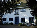
Villa in Rotterdam-Kralingen  | |||||
| Upload media | |||||
| Instance of | |||||
|---|---|---|---|---|---|
| Location | Rotterdam, South Holland, Netherlands | ||||
| Street address |
| ||||
| Heritage designation |
| ||||
 | |||||
Nederlands: De Boogerd
|
This is a category about rijksmonument number 46866
|
| Address |
|
Media in category "De Boogerd (Kralingen)"
The following 4 files are in this category, out of 4 total.
-
 Achtergevel - Kralingen - 20127585 - RCE.jpg 3,058 × 3,088; 2.39 MB
-
 Rotterdam gravenweg69.jpg 2,200 × 1,650; 508 KB
-
 Voorgevel "De Boogerd" - Kralingen - 20127584 - RCE.jpg 1,192 × 1,200; 398 KB
-
 Woonhuis Van der Mandele - Van der Mandele House (4440346707).jpg 1,280 × 955; 212 KB


.jpg)