Category:De Eendragt, Eanjum
Jump to navigation
Jump to search
| Object location | | View all coordinates using: OpenStreetMap |
|---|
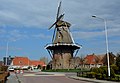
mill and museum in Anjum, the Netherlands  | |||||
| Upload media | |||||
| Instance of | |||||
|---|---|---|---|---|---|
| Location |
| ||||
| Street address |
| ||||
| Located on street |
| ||||
| Has use | |||||
| Heritage designation |
| ||||
| Source of energy | |||||
 | |||||
|
This is a category about rijksmonument number 31556
|
| Address |
|
Media in category "De Eendragt, Eanjum"
The following 36 files are in this category, out of 36 total.
-
 2022 Eanjum, mûne De Iendracht.jpg 3,948 × 2,805; 4.32 MB
-
 2022 Eanjum, nôtmûne 'De Iendracht'.jpg 2,604 × 2,606; 3.78 MB
-
 2023 De Iendracht yn Eanjum.jpg 1,831 × 1,832; 1.69 MB
-

-

-

-
 B 190, aanzicht - Anjum - 20022559 - RCE.jpg 1,200 × 806; 181 KB
-
 Dongeradiel Eanjum Moune.jpg 1,536 × 2,048; 892 KB
-
 Dorpsoverzichten - Anjum - 20022610 - RCE.jpg 1,185 × 1,200; 279 KB
-
 Dorpsoverzichten - Anjum - 20022613 - RCE.jpg 1,195 × 1,200; 360 KB
-
 Dorpsoverzichten - Anjum - 20022615 - RCE.jpg 1,197 × 1,200; 375 KB
-
 Eanjum, Mûne "De Iendracht".jpg 5,314 × 3,680; 6.38 MB
-
 Interieur achtkante stellingmolen - AMR Molenfoto - 20538763 - RCE.jpg 1,200 × 900; 177 KB
-
 Interieur achtkante stellingmolen - AMR Molenfoto - 20538764 - RCE.jpg 1,200 × 900; 119 KB
-
 Interieur achtkante stellingmolen - AMR Molenfoto - 20538765 - RCE.jpg 1,200 × 900; 175 KB
-
 Interieur achtkante stellingmolen - AMR Molenfoto - 20538766 - RCE.jpg 1,200 × 900; 139 KB
-
 Interieur achtkante stellingmolen - AMR Molenfoto - 20538767 - RCE.jpg 1,200 × 900; 185 KB
-
 Interieur achtkante stellingmolen - AMR Molenfoto - 20538768 - RCE.jpg 900 × 1,200; 125 KB
-
 Koren en pel-molen "De Eendracht, overzicht - Anjum - 20022574 - RCE.jpg 1,200 × 1,200; 230 KB
-
 Koren-en pelmolen "De eendracht", interieur museum - Anjum - 20022581 - RCE.jpg 1,200 × 1,200; 213 KB
-
 Koren-en pelmolen "De Eendracht", museum 2e zolder - Anjum - 20022577 - RCE.jpg 1,200 × 1,197; 240 KB
-
 Koren-en pelmolen "De Eendracht", museum 2e zolder - Anjum - 20022578 - RCE.jpg 1,200 × 1,200; 202 KB
-

-

-
 Korenmolen - Anjum - 20022568 - RCE.jpg 797 × 1,200; 165 KB
-
 Korenmolen, aanzicht - Anjum - 20022565 - RCE.jpg 979 × 1,200; 259 KB
-
 Korenmolen, aanzicht - Anjum - 20022566 - RCE.jpg 957 × 1,200; 244 KB
-
 Korenmolen, aanzicht - Anjum - 20022567 - RCE.jpg 788 × 1,200; 258 KB
-

-

-
 Molen "De Eendracht", exterieur - Anjum - 20022571 - RCE.jpg 955 × 1,200; 281 KB
-
 Molen "De Eendracht", exterieur - Anjum - 20022572 - RCE.jpg 950 × 1,200; 204 KB
-
 Molen,"De Eendracht", exterieur - Anjum - 20022573 - RCE.jpg 956 × 1,200; 189 KB
-
 Overzicht van de molen - Anjum - 20420720 - RCE.jpg 800 × 1,200; 159 KB
-
 Overzicht van de molen - Anjum - 20420721 - RCE.jpg 1,200 × 800; 139 KB
-
 Overzicht van de molen - Anjum - 20420722 - RCE.jpg 1,200 × 799; 145 KB


