Category:De Korenbloem, Zoelen
Jump to navigation
Jump to search
| Object location | | View all coordinates using: OpenStreetMap |
|---|
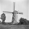
windmill in Zoelen, Netherlands  | |||||
| Upload media | |||||
| Instance of |
| ||||
|---|---|---|---|---|---|
| Location | Zoelen, Buren, Gelderland, Netherlands | ||||
| Street address |
| ||||
| Located on street |
| ||||
| Has use | |||||
| Heritage designation |
| ||||
| Source of energy | |||||
 | |||||
|
This is a category about rijksmonument number 11435
|
| Address |
|
Media in category "De Korenbloem, Zoelen"
The following 9 files are in this category, out of 9 total.
-
 Detail molenromp - Zoelen - 20224402 - RCE.jpg 788 × 1,200; 283 KB
-
 Gezicht vanuit het zuid-westen - Zoelen - 20224227 - RCE.jpg 1,200 × 1,173; 388 KB
-
 Korenmolen "De Korenbloem", aanzicht - Zoelen - 20224398 - RCE.jpg 807 × 1,200; 197 KB
-
 Korenmolen "De Korenbloem", overzicht - Zoelen - 20224403 - RCE.jpg 1,200 × 1,177; 284 KB
-
 Korenmolen "De Korenbloem", overzicht - Zoelen - 20224404 - RCE.jpg 1,200 × 1,181; 247 KB
-
 Molen De Korenbloem in Zoelen.jpg 4,770 × 3,177; 2.53 MB
-
 Molenromp - Zoelen - 20224401 - RCE.jpg 788 × 1,200; 274 KB
-
 Overzicht silhouet - Zoelen - 20224229 - RCE.jpg 1,200 × 963; 293 KB
-
 Zoelen - molen De Korenbloem.jpg 1,300 × 1,949; 1.42 MB


