Category:De Mars, De Blesse
Jump to navigation
Jump to search
| Object location | | View all coordinates using: OpenStreetMap |
|---|
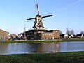
windmill in De Blesse, Netherlands  | |||||
| Upload media | |||||
| Instance of | |||||
|---|---|---|---|---|---|
| Location | De Blesse, Weststellingwerf, Friesland, Netherlands | ||||
| Street address |
| ||||
| Has use | |||||
| Heritage designation |
| ||||
| Source of energy | |||||
 | |||||
|
This is a category about rijksmonument number 527616
|
| Address |
|
Media in category "De Mars, De Blesse"
The following 2 files are in this category, out of 2 total.
-
 2023 De Blesse, nôtmûne De Mars.jpg 2,252 × 2,254; 1.54 MB
-
 8362 De Blesse.JPG 2,288 × 1,712; 2.15 MB
