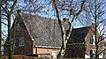
Category:De Voskuyl 17, Oegstgeest
Jump to navigation
Jump to search
| Object location | | View all coordinates using: OpenStreetMap |
|---|
 | |||||
| Upload media | |||||
| Instance of | |||||
|---|---|---|---|---|---|
| Location | Oegstgeest, South Holland, Netherlands | ||||
| Street address |
| ||||
| Located on street | |||||
| Heritage designation |
| ||||
 | |||||
|
This is a category about rijksmonument number 31246
|
| Address |
|
Media in category "De Voskuyl 17, Oegstgeest"
The following 9 files are in this category, out of 9 total.
-
 Aanzicht - Oegstgeest - 20171109 - RCE.jpg 1,200 × 807; 273 KB
-
 Aanzicht - Oegstgeest - 20171113 - RCE.jpg 1,200 × 811; 246 KB
-
 De Voscuyl 17.jpg 2,474 × 1,380; 1.23 MB
-
 Exterieur overzicht - Oegstgeest - 20171110 - RCE.jpg 1,200 × 1,005; 360 KB
-
 Exterieur overzicht - Oegstgeest - 20171111 - RCE.jpg 1,200 × 950; 293 KB
-
 Exterieur overzicht - Oegstgeest - 20171112 - RCE.jpg 967 × 1,200; 347 KB
-
 Overzicht - Oegstgeest - 20171114 - RCE.jpg 1,200 × 793; 209 KB
-
 Voor- en gedeelte linker zijgevel - Oegstgeest - 20171116 - RCE.jpg 798 × 1,200; 298 KB
-
 Voor- en rechter zijgevel - Oegstgeest - 20171115 - RCE.jpg 1,200 × 791; 229 KB


