Category:December 2009 in Somerset
Jump to navigation
Jump to search
Ok
Deutsch: Bilder, die im Dezember 2009 in Somerset aufgenommen worden sind. Bitte beachten Sie, dass dies weder das Datum des Uploads noch das Datum des Scannens eines Fotos ist.
English: Images/pictures taken in Somerset during December 2009. Note this is not the date of the upload, nor the date a photo was scanned.
Español: Fotografías o imágenes tomadas en Somerset durante diciembre 2009. No es la fecha de subida ni escaneo, sino la fecha en que las fotografías o imágenes se crearon.
Esperanto: Bildoj faritaj en Somerset en decembro 2009. Tio ne estas la dato, kiam la bildoj estis alŝutitaj aŭ skanitaj.
Français : Photographies ou images prises en Somerset durant décembre 2009. Ce n'est pas la date du téléchargement ou du scan.
Galego: Fotografías ou imaxes tomadas en Somerset durante decembro 2009. Non é a data de subida nin escaneamento, senón a data na que se crearon as fotografías ou imaxes.
Italiano: Fotografie o immagini scattate a Somerset nel dicembre 2009. Nota bene: la data non si riferisce né a quella di upload né a quella in cui la foto è stata digitalizzata.
Norsk bokmål: Bilder tatt i Somerset i løpet av desember 2009. Merk at dette ikke er datoen for opplasting, eller når et bilde har blitt skannet.
Norsk nynorsk: Bilete teke i Somerset i løpet av desember 2009. Merk at dette ikkje er datoen for opplasting, eller når eit bilete har vorte skanna.
Русский: Изображения, сделанные в Somerset в течение декабрь 2009 (не дата загрузки изображения).
Українська: Зображення, зроблені в Somerset протягом грудень 2009. Зауважте, що це не дата завантаження чи дата сканування фотографії.
| December 2008 | ← | December 2009 | → | December 2010 | |||||||
| Jan | Feb | Mar | Apr | May | Jun | Jul | Aug | Sep | Oct | Nov | Dec |
| 84 | 69 | 177 | 116 | 94 | 121 | 86 | 155 | 63 | 19 | 31 | 66 |
|---|---|---|---|---|---|---|---|---|---|---|---|
Subcategories
This category has the following 4 subcategories, out of 4 total.
Media in category "December 2009 in Somerset"
The following 62 files are in this category, out of 62 total.
-
 The Pastels @ ATP Nightmare before X mas (4302584626).jpg 725 × 1,024; 117 KB
-
 Bilinda Butcher - ATP 2009.jpg 1,536 × 2,048; 634 KB
-
 BilindaButcher2.jpg 807 × 1,024; 415 KB
-
 West Somerset Community College.jpg 640 × 389; 49 KB
-
 Mallard Road, Minehead - geograph.org.uk - 1623347.jpg 640 × 480; 232 KB
-
 Seaward Way, Minehead - geograph.org.uk - 1623357.jpg 640 × 480; 236 KB
-
 2009 at Crewkerne station - from the west.JPG 1,366 × 910; 380 KB
-
 2009 at Crewkerne station - main building.jpg 1,024 × 614; 183 KB
-
 2009 at Crewkerne station - old goods shed.jpg 1,024 × 768; 267 KB
-
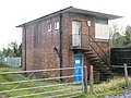 2009 at Crewkerne station - old signal box.jpg 1,024 × 768; 299 KB
-
 2009 at Crewkerne station - pump house.JPG 1,366 × 910; 346 KB
-
 Washford River near Washford Mill - geograph.org.uk - 1705805.jpg 640 × 480; 118 KB
-
 Washford River - geograph.org.uk - 4274240.jpg 640 × 480; 105 KB
-
 Geograph 1644441 St Andrew's Church.jpg 640 × 614; 87 KB
-
 Higher Town, Minehead-houses on hillside.jpg 640 × 463; 94 KB
-
 Statue of Queen Anne, Minehead.jpg 640 × 591; 108 KB
-
 Barn, Escott Farm - geograph.org.uk - 1654041.jpg 640 × 430; 104 KB
-
 Capton Farm - geograph.org.uk - 1654752.jpg 640 × 430; 124 KB
-
 Cattle overlooking porlock hill.jpg 1,936 × 1,296; 2.6 MB
-
 Cattle, Slowley Farm - geograph.org.uk - 1705959.jpg 640 × 480; 95 KB
-
 Celtic Cross, Stogumber - geograph.org.uk - 1653805.jpg 640 × 430; 122 KB
-
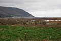
 Cliffs behind Hurlestone Point - geograph.org.uk - 1706920.jpg 640 × 478; 43 KB
-
 Conifer plantation near Escott Farm - geograph.org.uk - 1654012.jpg 640 × 430; 109 KB
-
 Crewkerne 159019.jpg 1,024 × 614; 156 KB
-
 Crossroads in Edington - geograph.org.uk - 1628231.jpg 640 × 480; 96 KB
-
 Dead trees, the marsh, Porlock Weir - geograph.org.uk - 1658735.jpg 640 × 430; 124 KB
-
 Dead trees, the marsh, Porlock Weir - geograph.org.uk - 1658741.jpg 640 × 430; 140 KB
-
 Dead trees, the marsh, Porlock Weir - geograph.org.uk - 1658785.jpg 640 × 430; 121 KB
-
 Dead trees, the marsh, Porlock Weir - geograph.org.uk - 1658795.jpg 640 × 430; 112 KB
-
 Entrance to Capton Farm and Quarry - geograph.org.uk - 1654728.jpg 640 × 430; 122 KB
-
 Escott farm - geograph.org.uk - 1654034.jpg 640 × 430; 117 KB
-
 Escott farm - geograph.org.uk - 1654037.jpg 640 × 414; 76 KB
-
 Escott Lane - geograph.org.uk - 1654062.jpg 640 × 430; 119 KB
-
 Escott Lane - geograph.org.uk - 1654069.jpg 640 × 430; 140 KB
-
 Escott Lane - geograph.org.uk - 1654075.jpg 640 × 430; 143 KB
-
 Farmhouse, Escott Farm - geograph.org.uk - 1654016.jpg 640 × 430; 114 KB
-
 Field, Capton Farm - geograph.org.uk - 1654770.jpg 640 × 430; 129 KB
-

-

-
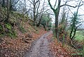 Footpath up Bicknoller Hill - geograph.org.uk - 1655731.jpg 640 × 430; 202 KB
-
 Harbour Arm, Minehead - geograph.org.uk - 1705712.jpg 640 × 480; 69 KB
-

-

-

-
 Low tide, Minehead Harbour - geograph.org.uk - 1705690.jpg 640 × 451; 48 KB
-
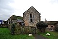 Lynch Chapel, West Lynch - geograph.org.uk - 1658149.jpg 640 × 430; 122 KB
-
 Minehead Town Hall, The Parade (geograph 1644744).jpg 640 × 430; 138 KB
-
 Minehead Town Hall, The Parade (geograph 1645234).jpg 640 × 477; 107 KB
-
 Minehead train, West Somerset Railway - geograph.org.uk - 1651875.jpg 640 × 430; 143 KB
-
 Muddy path near Vellow Wood - geograph.org.uk - 1654564.jpg 640 × 430; 145 KB
-
 Old drainage channels - geograph.org.uk - 1658372.jpg 640 × 430; 128 KB
-
 Quantock Greenway - geograph.org.uk - 1656623.jpg 640 × 430; 158 KB
-
 Quantock Greenway - geograph.org.uk - 1656637.jpg 640 × 430; 196 KB
-
 Quantock Greenway - geograph.org.uk - 1656646.jpg 640 × 430; 199 KB
-
 Shell Petrol Station, Williton - geograph.org.uk - 1655142.jpg 640 × 501; 80 KB
-
 South West Coaches The Red Line Route 1.JPG 2,848 × 2,136; 1.46 MB
-
 Taunton GBRf 66844.jpg 1,024 × 768; 221 KB
-
 The marsh near Porlock Weir - geograph.org.uk - 1658715.jpg 640 × 430; 109 KB
-
 The road to Porlock Weir - geograph.org.uk - 1658899.jpg 640 × 430; 118 KB
-
-
 Tide out - geograph.org.uk - 1655155.jpg 640 × 430; 121 KB
-
 Weston Bampfylde Church Interior - geograph.org.uk - 1635465.jpg 640 × 480; 106 KB
.jpg)


.jpg)
.jpg)


