Category:Denkmal WK II (Kodersdorf)
Jump to navigation
Jump to search
| Object location | | View all coordinates using: OpenStreetMap |
|---|
.jpg) | |||||
| Upload media | |||||
| Instance of | |||||
|---|---|---|---|---|---|
| Location | Kodersdorf, Q879194, Görlitz, Saxony, Germany | ||||
| Street address |
| ||||
| Heritage designation | |||||
| Inception |
| ||||
 | |||||
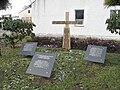
Deutsch: Denkmal für die Opfer der letzten Tage des Zweiten Weltkrieges in Kodersdorf bestehend aus einem Kreuz mit Spruch und drei Tafeln mit den Namen der Opfer
English: The memorial to the victims of the last days of World War II in Kodersdorf consisting of a cross with a bible verse and three plaques with the names of the victims.
Inschrift/inscription: Kreuz/Cross: „Hier ruhen Opfer aus den letzten Tagen des Zweiten Weltkrieges 1939-1945“
linke Tafel/left plaque: „Othmar Rakowski Gren. * 15.31924 + 3.5.1945 [... tbc]
Media in category "Denkmal WK II (Kodersdorf)"
The following 7 files are in this category, out of 7 total.
-
 Kodersdorf Denkmal der Opfer WK II (1).jpg 4,416 × 3,312; 8.02 MB
-
 Kodersdorf Denkmal der Opfer WK II (2).jpg 4,416 × 3,312; 6.59 MB
-
 Kodersdorf Denkmal der Opfer WK II (3).jpg 4,416 × 3,312; 8.45 MB
-
 Kodersdorf Denkmal der Opfer WK II (4).jpg 4,416 × 3,312; 9.23 MB
-
 Kodersdorf Denkmal der Opfer WK II (5).jpg 4,416 × 3,312; 7.28 MB
-
 Kodersdorf Denkmal der Opfer WK II (6).jpg 4,416 × 3,312; 7.04 MB
-
 Kodersdorf Denkmal der Opfer WK II (7).jpg 4,416 × 3,312; 7.14 MB
.jpg)
.jpg)
.jpg)
.jpg)
.jpg)
.jpg)