Category:Denkmalzone Ortskern (Gönnheim)
Jump to navigation
Jump to search
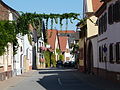
![]() Village center (Monument zone)
Village center (Monument zone)
- Bahnhofstraße 1, 3, 3 A, 5, 7, 9 und 13
- Bismarckstraße 2–30 (even numbers)
- Bismarckstraße 1–21 (odd numbers)
- Bismarckstraße 25-39 (odd numbers)
- Ludwigstraße 13–47 (odd numbers)
- Ludwigstraße 16–56 (even numbers)
- Hofgasse 1/2, 1, 2
- Village centre in the extension of the village around 1800
- Closed development of a typical farming community of two- and three-sided farmyards from the 18th and 19th century, barn wreath
| Object location | | View all coordinates using: OpenStreetMap |
|---|
Media in category "Denkmalzone Ortskern (Gönnheim)"
The following 4 files are in this category, out of 4 total.
-
 Goennheim OD 01.jpg 2,560 × 1,920; 2.37 MB
-
 Goennheim OD 02.jpg 2,560 × 1,920; 2.28 MB
-
 Goennheim OD 03.jpg 2,560 × 1,920; 2.33 MB
-
 Ludwigstraße - panoramio (3).jpg 1,977 × 1,917; 588 KB


.jpg)