Category:Dock retaining walls, South Ferry Basin
Jump to navigation
Jump to search
| Object location | | View all coordinates using: OpenStreetMap |
|---|
building in Liverpool, Merseyside, UK  | |||||
| Upload media | |||||
| Instance of | |||||
|---|---|---|---|---|---|
| Location | Liverpool, Merseyside, North West England, England | ||||
| Heritage designation |
| ||||
 | |||||
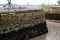
The dock walls of South Ferry Basin date to 1821 and are of sandstone with granite coping; they are Grade II listed.
Media in category "Dock retaining walls, South Ferry Basin"
The following 4 files are in this category, out of 4 total.
-
 East wall of South Ferry Basin.jpg 5,019 × 2,841; 8.59 MB
-
 Slipway and north wall of South Ferry Basin.jpg 4,917 × 3,314; 8.82 MB
-
 South wall of South Ferry Basin.jpg 4,854 × 3,243; 9.57 MB
-
 West wall of South Ferry Basin.jpg 4,797 × 3,233; 8.21 MB


