Category:Doktorshöhle (Muggendorf)
Jump to navigation
Jump to search
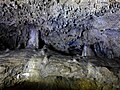
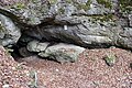
Deutsch: Die Doktorshöhle (HFA-Katasternummer: C 62) ist eine Karsthöhle bei Muggendorf. Sie ist als Bodendenkmal D-4-6133-0114 ausgewiesen.
| Object location | | View all coordinates using: OpenStreetMap |
|---|
cave in Germany _01.jpg) | |||||
| Upload media | |||||
| Instance of |
| ||||
|---|---|---|---|---|---|
| Location | Wiesenttal, Forchheim, Upper Franconia, Bavaria, Germany | ||||
| Heritage designation |
| ||||
| Elevation above sea level |
| ||||
 | |||||
Media in category "Doktorshöhle (Muggendorf)"
The following 8 files are in this category, out of 8 total.
-
 Doktorshoehle 2017a.jpg 2,400 × 1,800; 1.88 MB
-
 Doktorshoehle 2017b.jpg 2,400 × 1,800; 1.59 MB
-
 Doktorshoehle 2017c.jpg 2,400 × 1,800; 1.78 MB
-
 Doktorshöhle (C 62) 01.jpg 5,184 × 3,456; 4.89 MB
-
 Doktorshöhle (C 62) 02.jpg 5,184 × 3,456; 7.38 MB
-
 Doktorshöhle (C 62) 03.jpg 3,456 × 5,184; 4.74 MB
-
 Doktorshöhle (C 62) 04.jpg 5,184 × 3,456; 5.65 MB
-
 Doktorshöhle (C 62) 05.jpg 3,456 × 5,184; 4.23 MB


_02.jpg)
_03.jpg)
_04.jpg)
_05.jpg)