Category:Dolmen de Galuert
Jump to navigation
Jump to search
| Object location | | View all coordinates using: OpenStreetMap |
|---|
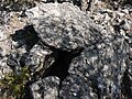
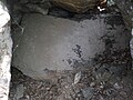
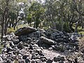
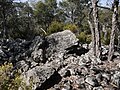
dolmen in Llauro, France  Vue rapprochée du Dolmen de Galuert depuis le nord | |||||
| Upload media | |||||
| Instance of | |||||
|---|---|---|---|---|---|
| Location | Llauro, canton of Thuir | ||||
 | |||||
Media in category "Dolmen de Galuert"
The following 16 files are in this category, out of 16 total.
-
 Dolmen de Galuert 1.JPG 2,816 × 2,112; 2.95 MB
-
 Dolmen de Galuert 10.JPG 2,816 × 2,112; 2.71 MB
-
 Dolmen de Galuert 11.JPG 2,816 × 2,112; 3 MB
-
 Dolmen de Galuert 12.JPG 2,112 × 2,816; 2.81 MB
-
 Dolmen de Galuert 13.JPG 2,816 × 2,112; 2.74 MB
-
 Dolmen de Galuert 14.JPG 2,816 × 2,112; 2.79 MB
-
 Dolmen de Galuert 15.JPG 2,816 × 2,112; 2.71 MB
-
 Dolmen de Galuert 16.JPG 2,816 × 2,112; 2.79 MB
-
 Dolmen de Galuert 2.JPG 2,816 × 2,112; 2.86 MB
-
 Dolmen de Galuert 3.JPG 2,816 × 2,112; 3.03 MB
-
 Dolmen de Galuert 4.JPG 2,816 × 2,112; 2.76 MB
-
 Dolmen de Galuert 5.JPG 2,816 × 2,112; 2.78 MB
-
 Dolmen de Galuert 6.JPG 2,816 × 2,112; 2.98 MB
-
 Dolmen de Galuert 7.JPG 2,816 × 2,112; 2.98 MB
-
 Dolmen de Galuert 8.JPG 2,112 × 2,816; 2.98 MB
-
 Dolmen de Galuert 9.JPG 2,816 × 2,112; 2.93 MB


