Category:Dolmen de Lesvariel
Jump to navigation
Jump to search
| Object location | | View all coordinates using: OpenStreetMap |
|---|
 | |||||
| Upload media | |||||
| Instance of | |||||
|---|---|---|---|---|---|
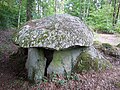
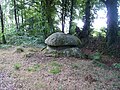
| Location | Guidel, canton of Pont-Scorff | ||||
 | |||||
Media in category "Dolmen de Lesvariel"
The following 7 files are in this category, out of 7 total.
-
 Dolmen de Lesvariel arrière.JPG 3,648 × 2,736; 4.81 MB
-
 Dolmen de Lesvariel côté.JPG 3,648 × 2,736; 4.86 MB
-
 Dolmen de Lesvariel entrée.JPG 3,648 × 2,736; 4.91 MB
-
 Dolmen de Lesvariel intérieur.JPG 2,736 × 3,648; 3.46 MB
-
 Dolmen de Lesvariel plafond.JPG 2,736 × 3,648; 2.98 MB
-
 Dolmen de Lesvariel1.JPG 3,648 × 2,736; 5.06 MB
-
 Dolmen de Lesvariel2.JPG 3,648 × 2,736; 4.88 MB


