Category:Dolmens de Mané-Kervilor
Jump to navigation
Jump to search
| Object location | | View all coordinates using: OpenStreetMap |
|---|
|
This building is classé au titre des monuments historiques de la France. It is indexed in the base Mérimée, a database of architectural heritage maintained by the French Ministry of Culture, under the reference PA00091768
|
 | |||||
| Upload media | |||||
| Instance of | |||||
|---|---|---|---|---|---|
| Location | La Trinité-sur-Mer, Morbihan, Brittany, Q88521114, Metropolitan France, France | ||||
| Street address |
| ||||
| Heritage designation |
| ||||
 | |||||
Media in category "Dolmens de Mané-Kervilor"
The following 5 files are in this category, out of 5 total.
-
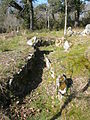 Mané Bras 1.JPG 2,304 × 3,072; 3.25 MB
-
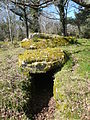
 Mané Bras 2 arrière.JPG 3,072 × 2,304; 2.77 MB
-
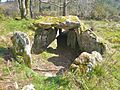
 Mané Bras 2.JPG 2,304 × 3,072; 3.2 MB
-
 Mané Bras 3.JPG 2,304 × 3,072; 2.93 MB
-
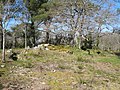 Vue d'ensemble dolmens Mané Bras.JPG 3,072 × 2,304; 3.11 MB


