Category:Dompfarramt (Eichstätt)
Jump to navigation
Jump to search
| Object location | | View all coordinates using: OpenStreetMap |
|---|
 | |||||
| Upload media | |||||
| Instance of | |||||
|---|---|---|---|---|---|
| Location | Eichstätt, Upper Bavaria, Bavaria, Germany | ||||
| Street address |
| ||||
| Heritage designation | |||||
 | |||||
This is the category of the Bavarian Baudenkmal (cultural heritage monument) with the ID D-1-76-123-177 (Wikidata)
|
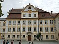
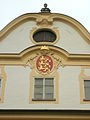
Pater-Philipp-Jeningen-Platz 4: Ehemalige Domkapiteltrinkstube, jetzt Dompfarramt. Dreiseitig freistehender dreigeschossiger Barockbau auf Grundlage der Vorgängerbauten von 1649 und 1510, mit Schweifgiebeln, Risalit, Erker und Stuckfassaden. 1749/50 von Giovanni Domenico Barbieri erbaut.
Media in category "Dompfarramt (Eichstätt)"
The following 12 files are in this category, out of 12 total.
-
 Dompfarramt Eichstätt .jpg 3,866 × 2,898; 6.15 MB
-
 GER Eichstätt, Pater-Philipp-Jeningen-Platz 001.jpg 3,883 × 2,912; 1.43 MB
-
 Leonrodplatz 4 Eichstätt Domdechantei.jpg 3,024 × 4,032; 5.53 MB
-
 Pater-Philipp-Jeningen-Platz 2 u 4 Eichstätt.jpg 2,048 × 1,536; 900 KB
-
 Pater-Philipp-Jeningen-Platz 4 Eichstaett-1.jpg 1,944 × 2,436; 632 KB
-
 Pater-Philipp-Jeningen-Platz 4 Eichstaett-2.jpg 1,944 × 2,385; 744 KB
-
 Pater-Philipp-Jeningen-Platz 4 Eichstätt -Infotafel.jpg 2,048 × 1,536; 908 KB
-
 Pater-Philipp-Jeningen-Platz 4 Eichstätt -Nordgiebel.jpg 1,536 × 2,048; 901 KB
-
 Pater-Philipp-Jeningen-Platz 4 Eichstätt -Nordseite.jpg 4,592 × 3,056; 6.47 MB
-
 Pater-Philipp-Jeningen-Platz 4 Eichstätt -Portal.jpg 1,536 × 2,048; 912 KB
-
 PPJ-Platz 4 Eichstätt -Fronleichnamschmuck (1).jpg 1,536 × 2,048; 884 KB
-
 PPJ-Platz 4 Eichstätt -Fronleichnamschmuck (2).jpg 1,536 × 2,048; 856 KB


.jpg)
.jpg)