Category:Donkere Gaard 25, Oudewater
Jump to navigation
Jump to search
| Object location | | View all coordinates using: OpenStreetMap |
|---|
 | |||||
| Upload media | |||||
| Instance of |
| ||||
|---|---|---|---|---|---|
| Location | Oudewater, South Holland, Netherlands | ||||
| Street address |
| ||||
| Located on street |
| ||||
| Heritage designation |
| ||||
 | |||||
|
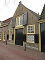
This is a category about rijksmonument number 32008
|
| Address |
|
Media in category "Donkere Gaard 25, Oudewater"
The following 7 files are in this category, out of 7 total.
-
 3421 Oudewater, Netherlands - panoramio (6).jpg 2,048 × 1,148; 513 KB
-
 Aanzicht - Oudewater - 20179819 - RCE.jpg 1,200 × 960; 320 KB
-
 RM32008 Oudewater - Donkere Gaard 25.jpg 1,944 × 2,592; 1.27 MB
-
 Voorgevel - Oudewater - 20179820 - RCE.jpg 1,200 × 954; 221 KB
-
 Voorgevel - Oudewater - 20179821 - RCE.jpg 949 × 1,200; 263 KB
-
 Voorgevel - Oudewater - 20179822 - RCE.jpg 956 × 1,200; 281 KB
-
 Voorgevel - Oudewater - 20179823 - RCE.jpg 806 × 1,200; 230 KB
.jpg)


