Category:Donkerstraat 34, Harderwijk
Jump to navigation
Jump to search
| Object location | | View all coordinates using: OpenStreetMap |
|---|
monumental house in the Netherlands | |||||
| Upload media | |||||
| Instance of |
| ||||
|---|---|---|---|---|---|
| Location | Harderwijk, Gelderland, Netherlands | ||||
| Street address |
| ||||
| Located on street |
| ||||
| Heritage designation |
| ||||
 | |||||
|
This is a category about rijksmonument number 20173
|
| Address |
|
Media in category "Donkerstraat 34, Harderwijk"
The following 7 files are in this category, out of 7 total.
-
 Achtergevel - Harderwijk - 20101028 - RCE.jpg 1,200 × 813; 239 KB
-
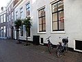 Donkerstraat 34 te Harderwijk.jpg 5,184 × 3,888; 7.64 MB
-
 Gevels - Harderwijk - 20101162 - RCE.jpg 809 × 1,200; 156 KB
-
 Overzicht - Harderwijk - 20101158 - RCE.jpg 1,190 × 1,200; 326 KB
-
 Overzicht - Harderwijk - 20101159 - RCE.jpg 1,192 × 1,200; 266 KB
-
 Overzicht achterzijde - Harderwijk - 20101160 - RCE.jpg 1,192 × 1,200; 440 KB
-
 Overzicht achterzijde - Harderwijk - 20101161 - RCE.jpg 1,197 × 1,200; 466 KB


