Category:Donkerstraat 36, Harderwijk
Jump to navigation
Jump to search
| Object location | | View all coordinates using: OpenStreetMap |
|---|
building in Harderwijk, Netherlands | |||||
| Upload media | |||||
| Instance of | |||||
|---|---|---|---|---|---|
| Location | Harderwijk, Gelderland, Netherlands | ||||
| Street address |
| ||||
| Located on street |
| ||||
| Heritage designation |
| ||||
 | |||||
|
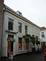
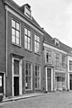
This is a category about rijksmonument number 20174
|
| Address |
|
Media in category "Donkerstraat 36, Harderwijk"
The following 15 files are in this category, out of 15 total.
-
 Donkerstraat 36 - Harderwijk.jpg 2,736 × 3,648; 3.51 MB
-
 Exterieur OVERZICHT - Harderwijk - 20288505 - RCE.jpg 1,192 × 1,200; 310 KB
-
 Gevel benedendeel - Harderwijk - 20101029 - RCE.jpg 1,200 × 1,188; 394 KB
-
 Gevel benedendeel - Harderwijk - 20101031 - RCE.jpg 1,200 × 1,188; 383 KB
-
 Gevel bovendeel - Harderwijk - 20101030 - RCE.jpg 1,200 × 1,192; 293 KB
-
 Gevels - Harderwijk - 20101162 - RCE.jpg 809 × 1,200; 156 KB
-
 Overzicht - Harderwijk - 20101032 - RCE.jpg 1,200 × 957; 259 KB
-
 Overzicht - Harderwijk - 20101033 - RCE.jpg 1,200 × 961; 234 KB
-
 Overzicht - Harderwijk - 20101158 - RCE.jpg 1,190 × 1,200; 326 KB
-
 Overzicht - Harderwijk - 20101159 - RCE.jpg 1,192 × 1,200; 266 KB
-
 Overzicht achterzijde - Harderwijk - 20101160 - RCE.jpg 1,192 × 1,200; 440 KB
-
 Overzicht achterzijde - Harderwijk - 20101161 - RCE.jpg 1,197 × 1,200; 466 KB
-
 Voorgevel - Harderwijk - 20101034 - RCE.jpg 1,200 × 953; 270 KB
-
 Voorgevel - Harderwijk - 20101036 - RCE.jpg 1,200 × 955; 239 KB
-
 Voorgevels - Harderwijk - 20101166 - RCE.jpg 802 × 1,200; 215 KB


