Category:Dorfkirche Reichenwalde
Jump to navigation
Jump to search
| Object location | | View all coordinates using: OpenStreetMap |
|---|
church church building in Brandenburg state, Germany   | |||||
| Upload media | |||||
| Instance of | |||||
|---|---|---|---|---|---|
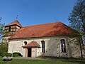
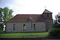
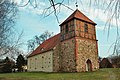
| Location | Reichenwalde, Oder-Spree District, Brandenburg, Germany | ||||
| Architectural style | |||||
| Heritage designation | |||||
 | |||||
This is the category of the Brandenburger Baudenkmal (cultural heritage monument) with the ID 09115449 (Wikidata)
|
Français : Église de Reichenwalde, arrondissement d'Oder-Spree, état fédéral de Brandebourg, Allemagne
Subcategories
This category has only the following subcategory.
I
Media in category "Dorfkirche Reichenwalde"
The following 12 files are in this category, out of 12 total.
-
 Dorfkirche Reichenwalde 2016 WSW.jpg 2,592 × 1,944; 2.28 MB
-
 Dorfkirche Reichenwalde Nordansicht.JPG 2,592 × 1,944; 1.93 MB
-
 Dorfkirche Reichenwalde Nordostansicht.JPG 2,592 × 1,944; 2.5 MB
-
 Dorfkirche Reichenwalde Nordwestansicht.JPG 2,592 × 1,944; 2.06 MB
-
 Dorfkirche Reichenwalde Ostansicht.JPG 2,592 × 1,944; 3.06 MB
-
 Dorfkirche Reichenwalde Portal Westturm.JPG 2,592 × 1,944; 3.3 MB
-
 Dorfkirche Reichenwalde Südansicht.JPG 2,592 × 1,944; 2.82 MB
-
 Dorfkirche Reichenwalde Westansicht.JPG 1,944 × 2,592; 1.73 MB
-
 Reichenwalde Dorfkirche asv2022-08.jpg 5,717 × 4,288; 13.58 MB
-
 Reichenwalde Kirche.jpg 3,872 × 2,592; 1.19 MB
-
 Reichenwalde, Blick zur Dorfkirche.jpg 2,551 × 1,701; 1.08 MB
-
 Reichenwalde, die Dorfkirche.jpg 2,551 × 1,701; 1.43 MB


