Category:Dorfkirche (Krugau)
Jump to navigation
Jump to search
| Object location | | View all coordinates using: OpenStreetMap |
|---|
church building in Brandenburg state, Germany   | |||||
| Upload media | |||||
| Instance of | |||||
|---|---|---|---|---|---|
| Location | Krugau, Märkische Heide, Dahme-Spreewald District, Brandenburg, Germany | ||||
| Heritage designation | |||||
 | |||||
This is the category of the Brandenburger Baudenkmal (cultural heritage monument) with the ID 09140138 (Wikidata)
|
Media in category "Dorfkirche (Krugau)"
The following 19 files are in this category, out of 19 total.
-
 Dorfkirche Krugau Denkmal Weltkriege.jpg 3,024 × 4,032; 5.26 MB
-
 Dorfkirche Krugau Nordostansicht.jpg 3,024 × 4,032; 3.07 MB
-
 Dorfkirche Krugau Ostansicht.jpg 3,024 × 4,032; 3.08 MB
-
 Dorfkirche Krugau Südansicht.jpg 4,032 × 3,024; 3.59 MB
-
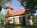 Dorfkirche Krugau Südostansicht.jpg 4,032 × 3,024; 4.26 MB
-
 Dorfkirche Krugau Südwestansicht.jpg 4,032 × 3,024; 4.55 MB
-
 Dorfkirche Krugau Vorhalle Südansicht.jpg 4,032 × 3,024; 3.64 MB
-
 Dorfkirche Krugau Westportal.jpg 4,032 × 3,024; 4.65 MB
-
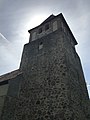 Dorfkirche Krugau Westturm Nordwestansicht.jpg 3,024 × 4,032; 2.08 MB
-
 Dorfkirche Krugau Westturm Südansicht.jpg 3,024 × 4,032; 3.01 MB
-
 Dorfkirche Krugau Westturm Westansicht.jpg 3,024 × 4,032; 3.29 MB
-
 Kirche Krugau Märkische Heide 01.jpg 6,016 × 4,000; 14.06 MB
-
 Kirche Krugau Märkische Heide 02.jpg 6,016 × 4,000; 18 MB
-
 Kirchenschiff Nordansicht.jpg 4,032 × 3,024; 2.53 MB
-
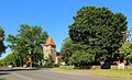 Krugau 01.JPG 5,192 × 3,163; 12.79 MB
-
 Krugau Dorfkirche 01.JPG 5,412 × 3,356; 13.58 MB
-
 Krugau Dorfkirche 02.JPG 5,427 × 3,623; 12.52 MB
-
 Krugau Dorfkirche Grabstein 01.JPG 3,358 × 5,037; 12.44 MB
-
 Pfarrhaus Krugau Märkische Heide.jpg 6,016 × 4,000; 14.39 MB


