Category:Dorfkirche (Leibchel)
Jump to navigation
Jump to search
| Object location | | View all coordinates using: OpenStreetMap |
|---|
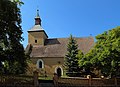
church building in Leibchel, Germany  | |||||
| Upload media | |||||
| Instance of | |||||
|---|---|---|---|---|---|
| Location | Märkische Heide, Dahme-Spreewald District, Brandenburg, Germany | ||||
| Heritage designation | |||||
 | |||||
This is the category of the Brandenburger Baudenkmal (cultural heritage monument) with the ID 09140144 (Wikidata)
|
Media in category "Dorfkirche (Leibchel)"
The following 7 files are in this category, out of 7 total.
-
 Dorfkirche Leibchel Ostseite.JPG 4,000 × 3,000; 3.92 MB
-
 Dorfkirche Leibchel Südwestseite.JPG 4,000 × 3,000; 4.31 MB
-
 Dorfkirche Leibchel Windfahne auf dem Turm.JPG 4,000 × 3,000; 1.57 MB
-
 Dorfkirche Leibchel Windfahne über dem Ostgiebel.JPG 4,000 × 3,000; 1.89 MB
-
 Dorfkirche Leibchel, Südseite.JPG 4,000 × 3,000; 3.68 MB
-
 Leibchel 01.JPG 5,472 × 3,648; 14.44 MB
-
 Leibchel Dorfkirche 01.JPG 4,929 × 3,558; 11.43 MB


