Category:Dorfkirche Arnsnesta
Jump to navigation
Jump to search
| Object location | | View all coordinates using: OpenStreetMap |
|---|
This is the category of the Brandenburger Baudenkmal (cultural heritage monument) with the ID 09135135 (Wikidata)
|
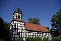
church building in Brandenburg state, Germany  | |||||
| Upload media | |||||
| Instance of | |||||
|---|---|---|---|---|---|
| Location | Arnsnesta, Herzberg (Elster), Elbe-Elster District, Brandenburg, Germany | ||||
| Street address |
| ||||
| Heritage designation | |||||
| Inception |
| ||||
| Religion or worldview | |||||
 | |||||
English: Pictures of the church in Arnsnesta, Herzberg (Elster) municipality, Elbe-Elster district, Brandenburg state, Deutschland.
Deutsch: Ansichten der Kirche in Arnsnesta, Stadt Herzberg (Elster) , Landkreis Elbe-Elster , Land Brandenburg , Germany.
Français : Photos de l'église à Arnsnesta, ville de Herzberg (Elster), , arrondissement de Elbe-Elster , état federé de Brandebourg , Allemagne.
Español: Vistas de la iglesia en Arnsnesta, ciudad de Herzberg (Elster), distrito de Elbe-Elster , estado federado de Brandeburgo , Alemania.
Address:
Arnsnesta 7, 04916 Herzberg (Elster)
Subcategories
This category has only the following subcategory.
I
Media in category "Dorfkirche Arnsnesta"
The following 5 files are in this category, out of 5 total.
-
 Church of Arnsnesta, Brandenburg. - panoramio.jpg 1,600 × 1,200; 410 KB
-
 Herzberg Elster Arnsnesta Kirche.jpg 3,872 × 2,592; 1.07 MB
-
 Kirche Arnsnesta 06 2014 01.JPG 3,648 × 2,736; 2.38 MB
-
 Kirche Arnsnesta 06 2014 02.JPG 2,736 × 3,648; 2.4 MB
-
 Kirche Arnsnesta 06 2014 03.JPG 2,736 × 3,648; 2.01 MB


