Category:Dorfkirche Atterwasch
Jump to navigation
Jump to search
| Object location | | View all coordinates using: OpenStreetMap |
|---|
church building in Brandenburg state, Germany   | |||||
| Upload media | |||||
| Instance of | |||||
|---|---|---|---|---|---|
| Location | Atterwasch, Schenkendöbern, Spree-Neiße District, Brandenburg, Germany | ||||
| Street address |
| ||||
| Heritage designation | |||||
 | |||||
This is the category of the Brandenburger Baudenkmal (cultural heritage monument) with the ID 09125048 (Wikidata)
|
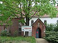
English: Pictures of the church in Atterwasch, Schenkendöbern municipality, Spree-Neiße district, Brandenburg state, Germany.
Deutsch: Ansichten der Kirche in Atterwasch, Gemeinde Schenkendöbern, Landkreis Spree-Neiße, Land Brandenburg, Deutschland.
Français : Photos de l'église à Atterwasch, commune de Schenkendöbern, arrondissement de Spree-Neiße, état fédéral de Brandebourg, Allemagne
Español: Vistas de la iglesia en Atterwasch, municipio de Schenkendöbern, distrito de Spree-Neiße, estado federado de Brandeburgo, Alemania
Address: Atterwascher Str. 51a, Atterwasch, 03172 Schenkendöbern
Subcategories
This category has the following 2 subcategories, out of 2 total.
I
P
- Pfarrhaus Atterwasch (2 F)
Media in category "Dorfkirche Atterwasch"
The following 2 files are in this category, out of 2 total.
-
 Atterwascher Dorfkirche.jpg 3,072 × 2,304; 4.21 MB
-
 Kirche in Atterwasch.jpg 800 × 600; 575 KB
