Category:Dorfkirche Berkholz
Jump to navigation
Jump to search
| Object location | | View all coordinates using: OpenStreetMap |
|---|
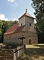
church building in Boitzenburger Land municipality _2018_NW.jpg) | |||||
| Upload media | |||||
| Instance of | |||||
|---|---|---|---|---|---|
| Location | Berkholz (Boitzenburger Land), Boitzenburger Land, Uckermark District, Brandenburg, Germany | ||||
| Heritage designation | |||||
 | |||||
This is the category of the Brandenburger Baudenkmal (cultural heritage monument) with the ID 09130360 (Wikidata)
|
English: Church in Berkholz, Boitzenburger Land municipality, Uckermark district, Brandenburg state, Germany
Deutsch: Kirche in Berkholz, Gemeinde Boitzenburger Land, Landkreis Uckermark, Land Brandenburg, Deutschland.
Français : Église de Berkholz, commune de Boitzenburger Land, arrondissement Uckermark, état fédéral de Brandebourg, Allemagne
Media in category "Dorfkirche Berkholz"
The following 8 files are in this category, out of 8 total.
-
 Dorfkirche Berkholz (Boitzenburger Land) 2018 ENE.jpg 4,864 × 3,648; 8.91 MB
-
 Dorfkirche Berkholz (Boitzenburger Land) 2018 N.jpg 4,730 × 3,464; 6 MB
-
 Dorfkirche Berkholz (Boitzenburger Land) 2018 NW.jpg 3,552 × 4,792; 7.01 MB
-
 Dorfkirche Berkholz (Boitzenburger Land) 2018 SSE.jpg 6,973 × 4,552; 13.41 MB
-
 Dorfkirche Berkholz (Boitzenburger Land) 2018 Südportal.jpg 3,564 × 4,802; 8.44 MB
-
 Dorfkirche Berkholz (Boitzenburger Land) 2018 Turm.jpg 3,648 × 4,864; 5.41 MB
-
 Dorfkirche Berkholz (Boitzenburger Land) 2018 Westportal.jpg 3,570 × 4,806; 8.55 MB
-
 Kirche in Berkholz. LK Uckermark - geo.hlipp.de - 9308.jpg 640 × 480; 107 KB
_2018_ENE.jpg)
_2018_N.jpg)
_2018_SSE.jpg)
_2018_S%C3%BCdportal.jpg)
_2018_Turm.jpg)
_2018_Westportal.jpg)
