Category:Dorfkirche Berlitt
Jump to navigation
Jump to search
| Object location | | View all coordinates using: OpenStreetMap |
|---|
church building in Brandenburg state, Germany   | |||||
| Upload media | |||||
| Instance of | |||||
|---|---|---|---|---|---|
| Location | Berlitt, Kyritz, Ostprignitz-Ruppin District, Brandenburg, Germany | ||||
| Heritage designation | |||||
 | |||||
This is the category of the Brandenburger Baudenkmal (cultural heritage monument) with the ID 09170518 (Wikidata)
|
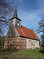
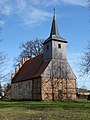
English: Pictures of the church in Berlitt, Kyritz municipality, Barnim district, Brandenburg state, Germany.
Deutsch: Ansichten der Kirche in Berlitt, Stadt Kyritz, Landkreis Barnim, Land Brandenburg, Deutschland.
Français : Photos de l'église à Berlitt, ville de Kyritz, arrondissement de Barnim, état fédéral de Brandebourg, Allemagne
Español: Vistas de la iglesia en Berlitt, ciudad de Kyritz, distrito de Barnim, estado federado de Brandeburgo, Alemania
Address: Berlitter Dorfstraße 43, 16866 Kyritz
Subcategories
This category has only the following subcategory.
I
Pages in category "Dorfkirche Berlitt"
This category contains only the following page.
Media in category "Dorfkirche Berlitt"
The following 8 files are in this category, out of 8 total.
-
 Berlitt. Turm von Südosten.png 693 × 1,141; 1.14 MB
-
 Dorfkirche Berlitt 2017 NE.jpg 3,522 × 4,772; 8.83 MB
-
 Dorfkirche Berlitt 2017 S.jpg 3,648 × 4,864; 7.29 MB
-
 Dorfkirche Berlitt 2017 SE.jpg 4,864 × 3,648; 6.16 MB
-
 Dorfkirche Berlitt 2017 Südportal.jpg 3,648 × 4,864; 7.59 MB
-
 Dorfkirche Berlitt 2017 W.jpg 3,648 × 4,864; 5.95 MB
-
 Kirche Berlitt.jpg 3,408 × 2,272; 1.88 MB
-
 Kyritz Berlitt church.jpg 1,260 × 1,500; 408 KB


