Category:Dorfkirche Burxdorf
Jump to navigation
Jump to search
| Object location | | View all coordinates using: OpenStreetMap |
|---|
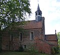
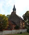
church building in Burxdorf, Germany  | |||||
| Upload media | |||||
| Instance of | |||||
|---|---|---|---|---|---|
| Location | Burxdorf, Bad Liebenwerda, Elbe-Elster District, Brandenburg, Germany | ||||
| Street address |
| ||||
| Heritage designation | |||||
| Inception |
| ||||
| Religion or worldview | |||||
 | |||||
This is the category of the Brandenburger Baudenkmal (cultural heritage monument) with the ID 09135474 (Wikidata)
|
Media in category "Dorfkirche Burxdorf"
The following 12 files are in this category, out of 12 total.
-
 Dorfkirche Burxdorf Nordportal P1060697.jpg 1,536 × 1,109; 446 KB
-
 Dorfkirche Burxdorf Nordseite P1060693 b.jpg 3,717 × 3,434; 2.27 MB
-
 Dorfkirche Burxdorf P1060659 b.jpg 880 × 943; 92 KB
-
 Dorfkirche Burxdorf P1060659.jpg 3,441 × 3,760; 2.67 MB
-
 Dorfkirche Burxdorf P1060678 b.jpg 1,693 × 1,390; 810 KB
-
 Dorfkirche Burxdorf P1060678.jpg 3,387 × 2,780; 2.58 MB
-
 Dorfkirche Burxdorf SJ Eda IMG 6722.jpg 1,986 × 2,929; 944 KB
-
 Dorfkirche Burxdorf SJ Eda IMG 6724.jpg 3,310 × 3,965; 1.77 MB
-
 Dorfkirche Burxdorf SJ Eda P1060690.jpg 2,636 × 2,755; 1.7 MB
-
 Gefallenendenkmal Burxdorf IMG 6726 b.jpg 3,771 × 2,086; 1.69 MB
-
 Grab des unbekannten Soldaten Burxdorf IMG 6730.jpg 2,756 × 2,849; 1.8 MB
-
 Trauerhalle Burxdorf IMG 6732.jpg 2,719 × 2,828; 1.53 MB


