Category:Dorfkirche Dannenberg/Mark
Jump to navigation
Jump to search
| Object location | | View all coordinates using: OpenStreetMap |
|---|
church building in Brandenburg state, Germany  | |||||
| Upload media | |||||
| Instance of | |||||
|---|---|---|---|---|---|
| Location | Dannenberg/Mark, Falkenberg, Märkisch-Oderland District, Brandenburg, Germany | ||||
| Heritage designation | |||||
 | |||||
This is the category of the Brandenburger Baudenkmal (cultural heritage monument) with the ID 09180407 (Wikidata)
|
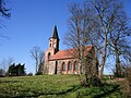
English: Pictures of the church in Dannenberg/Mark, Falkenberg (Mark) municipality, Märkisch-Oderland district, Brandenburg state, Germany
Deutsch: Bilder der Kirche in Dannenberg/Mark, Gemeinde Falkenberg (Mark), Landkreis Märkisch-Oderland, Land Brandenburg, Deutschland.
Français : Photos de l'église à Dannenberg/Mark, commune de Falkenberg (Mark), arrondissement de Märkisch-Oderland, état fédéral de Brandebourg, Allemagne
Media in category "Dorfkirche Dannenberg/Mark"
The following 8 files are in this category, out of 8 total.
-
 Dorfkirche Dannenberg (Mark).JPG 4,320 × 3,240; 4.74 MB
-
 Dorfkirche Dannenberg-Mark 2018 NNE.jpg 3,853 × 3,627; 5.75 MB
-
 Dorfkirche Dannenberg-Mark 2018 S.jpg 4,864 × 3,426; 6.86 MB
-
 Dorfkirche Dannenberg-Mark 2018 SE.jpg 4,255 × 4,741; 13.17 MB
-
 Dorfkirche Dannenberg-Mark 2018 SSW.jpg 3,442 × 4,211; 6.93 MB
-
 Dorfkirche Dannenberg-Mark 2018 Turmhaube.jpg 3,648 × 4,864; 3.96 MB
-
 Dorfkirche Dannenberg-Mark 2018 Westportal.jpg 3,558 × 4,798; 6.87 MB
-
 Dorfkirche Dannenberg-Mark.jpg 6,123 × 4,082; 7.3 MB
.JPG)


