Category:Dorfkirche Dauer
Jump to navigation
Jump to search
| Object location | | View all coordinates using: OpenStreetMap |
|---|
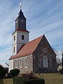
church building in Prenzlau, Landkreis Uckermark, Brandenburg, Germany _2018_SE.jpg) | |||||
| Upload media | |||||
| Instance of | |||||
|---|---|---|---|---|---|
| Location | Dauer (Prenzlau), Prenzlau, Uckermark District, Brandenburg, Germany | ||||
| Heritage designation | |||||
 | |||||
This is the category of the Brandenburger Baudenkmal (cultural heritage monument) with the ID 09130029 (Wikidata)
|
Français : Église de Dauer, ville de Prenzlau, arrondissement Uckermark, état fédéral de Brandebourg, Allemagne
Media in category "Dorfkirche Dauer"
The following 11 files are in this category, out of 11 total.
-
 DauerKirche.JPG 4,608 × 3,456; 2.34 MB
-
 Dorfkirche Dauer (Prenzlau) 2018 E.jpg 3,564 × 4,802; 5.38 MB
-
 Dorfkirche Dauer (Prenzlau) 2018 ENE.jpg 3,960 × 4,629; 7.84 MB
-
 Dorfkirche Dauer (Prenzlau) 2018 N Panorama.jpg 7,297 × 3,581; 9.61 MB
-
 Dorfkirche Dauer (Prenzlau) 2018 NE.jpg 3,490 × 4,750; 4.53 MB
-
 Dorfkirche Dauer (Prenzlau) 2018 NW.jpg 4,246 × 3,493; 4.87 MB
-
 Dorfkirche Dauer (Prenzlau) 2018 S Panorama.jpg 4,864 × 3,648; 4.87 MB
-
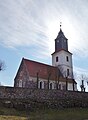
 Dorfkirche Dauer (Prenzlau) 2018 SE.jpg 3,648 × 4,864; 4.48 MB
-
 Dorfkirche Dauer (Prenzlau) 2018 Turm.jpg 3,848 × 4,645; 5.92 MB
-
 Dorfkirche Dauer (Prenzlau) 2018 Vermauertes Nordportal.jpg 3,648 × 4,864; 5.67 MB
-
 Dorfkirche Dauer (Prenzlau) 2018 Westportal.jpg 3,530 × 4,778; 4.14 MB

_2018_E.jpg)
_2018_ENE.jpg)
_2018_N_Panorama.jpg)
_2018_NE.jpg)
_2018_NW.jpg)
_2018_S_Panorama.jpg)
_2018_Turm.jpg)
_2018_Vermauertes_Nordportal.jpg)
_2018_Westportal.jpg)