Category:Dorfkirche Gröben (Ludwigsfelde)
Jump to navigation
Jump to search
| Object location | | View all coordinates using: OpenStreetMap |
|---|
church building in Teltow-Fläming district, Brandenburg state, Germany  | |||||
| Upload media | |||||
| Instance of | |||||
|---|---|---|---|---|---|
| Location | Gröben, Ludwigsfelde, Teltow-Fläming District, Brandenburg, Germany | ||||
| Street address |
| ||||
| Heritage designation | |||||
| Inception |
| ||||
| Beam |
| ||||
| Width |
| ||||
| Length |
| ||||
| Area |
| ||||
| Religion or worldview | |||||
 | |||||
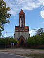
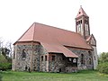
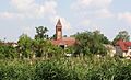
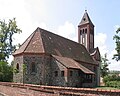
This is the category of the Brandenburger Baudenkmal (cultural heritage monument) with the ID 09105156 (Wikidata)
|
English: Pictures of the church in Gröben, Ludwigsfelde municipality, Teltow-Fläming district, Brandenburg state, Germany.
Deutsch: Ansichten der Kirche in Gröben, Stadt Ludwigsfelde , Landkreis Teltow-Fläming , Land Brandenburg , Deutschland.
Français : Photos de l'église à Gröben, ville de Ludwigsfelde, , arrondissement de Teltow-Fläming , état federé de Brandebourg , Allemagne.
Español: Vistas de la iglesia en Gröben, ciudad de Ludwigsfelde, distrito de Teltow-Fläming , estado federado de Brandeburgo , Alemania.
Address: Gröbener Dorfstraße 41, 14974 Ludwigsfelde
Subcategories
This category has only the following subcategory.
Media in category "Dorfkirche Gröben (Ludwigsfelde)"
The following 14 files are in this category, out of 14 total.
-
 Dorfkirche Gröben (Ludwigsfelde) 2019 ESE.jpg 3,648 × 4,864; 6.27 MB
-
 Dorfkirche Gröben (Ludwigsfelde) 2019 NE.jpg 4,864 × 3,648; 3.38 MB
-
 Dorfkirche Gröben (Ludwigsfelde) 2019 SW.jpg 3,648 × 4,864; 6.12 MB
-
 Dorfkirche Gröben (Ludwigsfelde) 2019 Turm.jpg 3,604 × 4,805; 2.58 MB
-
 Dorfkirche Gröben (Ludwigsfelde) 2019 Turmhaube.jpg 3,648 × 4,864; 4.36 MB
-
 Dorfkirche Gröben (Ludwigsfelde) 2019 Türbeschlag.jpg 4,864 × 3,648; 6.11 MB
-
 Dorfkirche Gröben (Ludwigsfelde) 2019 W.jpg 3,648 × 4,864; 5.38 MB
-
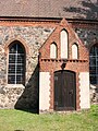
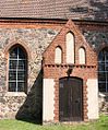
 Dorfkirche Gröben (Ludwigsfelde) 2019 Westportal.jpg 3,438 × 4,583; 3.27 MB
-
 Dorfkirche Gröben - panoramio.jpg 3,264 × 2,448; 3.06 MB
-
 Gröben Ansicht.JPG 718 × 435; 75 KB
-
 Kirche 1 Gröben.JPG 1,483 × 1,184; 275 KB
-
 Kirche 2 Gröben.JPG 1,200 × 1,600; 392 KB
-
 Kirche Gröben Süd.JPG 418 × 504; 67 KB
-
 Kirche Gröben.JPG 560 × 420; 55 KB
_2019_ESE.jpg)
_2019_NE.jpg)
_2019_SW.jpg)
_2019_Turm.jpg)
_2019_Turmhaube.jpg)
_2019_T%C3%BCrbeschlag.jpg)
_2019_W.jpg)
_2019_Westportal.jpg)


Categories:
- Gröben (Ludwigsfelde)
- Fieldstone churches in Brandenburg
- Churches in Brandenburg built in 1508
- Destroyed in Germany in 1908
- Churches in Brandenburg built in 1909
- Franz Schwechten
- Gothic Revival churches in Brandenburg
- Churches in Kirchenkreis Zossen-Fläming
- Lutheran churches in Brandenburg
- Cultural heritage monuments in Ludwigsfelde
- Churches in Ludwigsfelde