Category:Dorfkirche Grütz
Jump to navigation
Jump to search
| Object location | | View all coordinates using: OpenStreetMap |
|---|
church building in Brandenburg state, Germany   | |||||
| Upload media | |||||
| Instance of | |||||
|---|---|---|---|---|---|
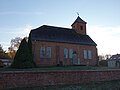
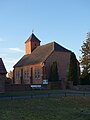
| Location | Grütz, Rathenow, Havelland District, Brandenburg, Germany | ||||
| Heritage designation | |||||
| Inception |
| ||||
 | |||||
Français : Église de Grütz, ville de Rathenow, arrondissement Pays de la Havel, état fédéral de Brandebourg, Allemagne
This is the category of the Brandenburger Baudenkmal (cultural heritage monument) with the ID 09150535 (Wikidata)
|
Subcategories
This category has the following 2 subcategories, out of 2 total.
I
- Interior of Dorfkirche Grütz (12 F)
K
- Kriegerdenkmal Grütz (3 F)
Media in category "Dorfkirche Grütz"
The following 12 files are in this category, out of 12 total.
-
 Dorfkirche Grütz 2016 N.jpg 4,864 × 3,648; 4.39 MB
-
 Dorfkirche Grütz 2016 NW (bearb Sp).jpg 4,358 × 3,268; 3.6 MB
-
 Dorfkirche Grütz 2016 NW.jpg 4,864 × 3,648; 3.78 MB
-
 Dorfkirche Grütz 2016 Portal W.jpg 3,648 × 4,864; 6.89 MB
-
 Dorfkirche Grütz 2016 SE.jpg 3,648 × 4,864; 4.71 MB
-
 Dorfkirche Grütz 2016 SW.jpg 4,864 × 3,648; 4.36 MB
-
 Dorfkirche Grütz 2016 W.jpg 4,864 × 3,648; 4.1 MB
-
 Dorfkirche grütz 2021-10-09 12.jpg 3,648 × 2,736; 3.09 MB
-
 Dorfkirche grütz 2021-10-09 13.jpg 3,648 × 2,736; 3.15 MB
-
 Dorfkirche grütz 2021-10-09 14.jpg 3,648 × 2,736; 2.65 MB
-
 Dorfkirche grütz 2021-10-09 18.jpg 3,648 × 2,736; 2.58 MB
-
 Dorfkirche Grütz mit Trafoturm.JPG 4,320 × 3,240; 2.51 MB

.jpg)


