Category:Dorfkirche Herzsprung (Angermünde)
Jump to navigation
Jump to search
| Object location | | View all coordinates using: OpenStreetMap |
|---|
 | |||||
| Upload media | |||||
| Instance of | |||||
|---|---|---|---|---|---|
| Location | Herzsprung (Angermünde), Angermünde, Uckermark District, Brandenburg, Germany | ||||
| Heritage designation | |||||
 | |||||
This is the category of the Brandenburger Baudenkmal (cultural heritage monument) with the ID 09130507 (Wikidata)
|
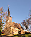
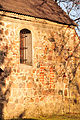
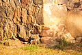
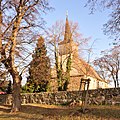
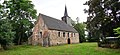
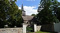
English: Church in Herzsprung, Angermünde municipality, Uckermark district, Brandenburg state, Germany. It is owned by a congregation within the Evangelical Church of Berlin-Brandenburg-Silesian Upper Lusatia, a united Protestant church body of Calvinist, Lutheran and united congregations. The church was erected in 1695/96, after the predecessor had been burnt down.
Deutsch: Kirche in Herzsprung, Stadt Angermünde, Landkreis Uckermark, Land Brandenburg, Deutschland. Sie gehört einer Gemeinde der unierten Evangelischen Kirche Berlin-Brandenburg-Schlesische Oberlausitz. Die Kirche entstand 1695/96 nachdem die Vorgängerin abgebrannt war.
Français : Église de Herzsprung, ville de Angermünde, arrondissement Uckermark, état fédéral de Brandebourg, Allemagne
Media in category "Dorfkirche Herzsprung (Angermünde)"
The following 39 files are in this category, out of 39 total.
-
 11-11-28-angermuende-18.jpg 9,205 × 10,931; 40.8 MB
-
 11-11-28-angermuende-19.jpg 4,288 × 2,848; 4.74 MB
-
 11-11-28-angermuende-20.jpg 2,848 × 4,288; 4.78 MB
-
 11-11-28-angermuende-21.jpg 2,848 × 4,288; 4.91 MB
-
 11-11-28-angermuende-22.jpg 2,848 × 2,848; 2.16 MB
-
 11-11-28-angermuende-23.jpg 2,848 × 4,288; 3.39 MB
-
 11-11-28-angermuende-24.jpg 2,848 × 4,288; 3.61 MB
-
 11-11-28-angermuende-25.jpg 4,288 × 2,848; 4.79 MB
-
 11-11-28-angermuende-26.jpg 4,288 × 2,848; 4.68 MB
-
 11-11-28-angermuende-27.jpg 4,324 × 4,324; 6.18 MB
-
 11-11-28-angermuende-30.jpg 2,848 × 4,288; 6.3 MB
-
 11-11-28-angermuende-31.jpg 2,848 × 4,288; 5.05 MB
-
 11-11-28-angermuende-32.jpg 2,848 × 4,288; 4.32 MB
-
 11-11-28-angermuende-33.jpg 2,848 × 4,288; 4.56 MB
-
 11-11-28-angermuende-34.jpg 2,848 × 4,288; 3.36 MB
-
 11-11-28-angermuende-35.jpg 4,288 × 2,848; 6.43 MB
-
 11-11-28-angermuende-39.jpg 2,848 × 2,848; 5.37 MB
-
 2010-12-26-herzsprung-by-RalfR-05.jpg 3,008 × 2,000; 1.59 MB
-
 2010-12-26-herzsprung-by-RalfR-06.jpg 2,000 × 3,008; 2.04 MB
-
 Herzsprung (Uckermark) 2020 -mix- by-RaBoe 17.jpg 5,120 × 2,368; 14.03 MB
-
 Herzsprung (Uckermark) 2020 -mix- by-RaBoe 18.jpg 5,120 × 2,368; 12.83 MB
-
 Herzsprung (Uckermark) 2020 -mix- by-RaBoe 19.jpg 2,368 × 5,120; 10.37 MB
-
 Herzsprung (Uckermark) 2020 -mix- by-RaBoe 20.jpg 5,120 × 2,368; 12.52 MB
-
 Herzsprung (Uckermark) 2020 -mix- by-RaBoe 21.jpg 5,120 × 2,368; 13.28 MB
-
 Herzsprung (Uckermark) 2020 -mix- by-RaBoe 22.jpg 5,120 × 2,368; 13.57 MB
-
 Herzsprung (Uckermark) 2020 -mix- by-RaBoe 23.jpg 3,584 × 3,072; 8.69 MB
-
 Herzsprung (Uckermark) 2020 -mix- by-RaBoe 24.jpg 2,368 × 3,200; 5.55 MB
-
 Herzsprung (Uckermark) 2020 -mix- by-RaBoe 25.jpg 2,368 × 3,200; 6.65 MB
-
 Herzsprung (Uckermark) 2020 -mix- by-RaBoe 26.jpg 4,800 × 3,136; 12.48 MB
-
 Herzsprung (Uckermark) 2020 -mix- by-RaBoe 27.jpg 3,584 × 3,072; 9.07 MB
-
 Herzsprung (Uckermark) 2020 -mix- by-RaBoe 28.jpg 3,584 × 3,072; 9.59 MB
-
 Herzsprung (Uckermark) 2020 -mix- by-RaBoe 29.jpg 5,120 × 2,368; 12.24 MB
-
 Herzsprung (Uckermark) 2020 -mix- by-RaBoe 30.jpg 5,120 × 2,368; 11.97 MB
-
 Herzsprung (Uckermark) 2020 -mix- by-RaBoe 31.jpg 5,120 × 2,368; 12.09 MB
-
 Herzsprung (Uckermark) 2020 -mix- by-RaBoe 32.jpg 3,648 × 1,680; 7.09 MB
-
 Herzsprung (Uckermark) 2020 -mix- by-RaBoe 33.jpg 3,648 × 1,680; 7.02 MB
-
 Herzsprung (Uckermark) Dorfkirche 01.jpg 3,600 × 2,825; 2.66 MB
-
 Herzsprung (Uckermark) Dorfkirche 02.jpg 2,736 × 3,248; 1.55 MB
-
 Kirche in Herzsprung.jpg 3,968 × 2,232; 3.84 MB


_2020_-mix-_by-RaBoe_17.jpg)
_2020_-mix-_by-RaBoe_18.jpg)
_2020_-mix-_by-RaBoe_19.jpg)
_2020_-mix-_by-RaBoe_20.jpg)
_2020_-mix-_by-RaBoe_21.jpg)
_2020_-mix-_by-RaBoe_22.jpg)
_2020_-mix-_by-RaBoe_23.jpg)
_2020_-mix-_by-RaBoe_24.jpg)
_2020_-mix-_by-RaBoe_25.jpg)
_2020_-mix-_by-RaBoe_26.jpg)
_2020_-mix-_by-RaBoe_27.jpg)
_2020_-mix-_by-RaBoe_28.jpg)
_2020_-mix-_by-RaBoe_29.jpg)
_2020_-mix-_by-RaBoe_30.jpg)
_2020_-mix-_by-RaBoe_31.jpg)
_2020_-mix-_by-RaBoe_32.jpg)
_2020_-mix-_by-RaBoe_33.jpg)
_Dorfkirche_01.jpg)
_Dorfkirche_02.jpg)
