Category:Dorfkirche Hinzdorf
Jump to navigation
Jump to search
| Object location | | View all coordinates using: OpenStreetMap |
|---|
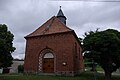
church building in Brandenburg state, Germany  | |||||
| Upload media | |||||
| Instance of | |||||
|---|---|---|---|---|---|
| Location | Hinzdorf, Wittenberge, Prignitz District, Brandenburg, Germany | ||||
| Heritage designation | |||||
 | |||||
This is the category of the Brandenburger Baudenkmal (cultural heritage monument) with the ID 09160656 (Wikidata)
|
Media in category "Dorfkirche Hinzdorf"
The following 3 files are in this category, out of 3 total.
-
 Dorfkirche Hinzdorf Wittenberge.jpg 3,872 × 2,592; 3.95 MB
-
 Hinzdorf - Dorfkirche W.jpg 2,592 × 3,888; 4.14 MB
-
 Hinzdorf - Kirche SO.jpg 3,744 × 2,592; 1.77 MB

