Category:Dorfkirche Jagow (Uckerland)
Jump to navigation
Jump to search
| Object location | | View all coordinates using: OpenStreetMap |
|---|
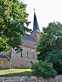
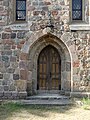
church building in Jagow, Uckerland municipality, Brandenburg state, Germany  | |||||
| Upload media | |||||
| Instance of | |||||
|---|---|---|---|---|---|
| Location | Jagow, Uckerland, Uckermark District, Brandenburg, Germany | ||||
| Heritage designation | |||||
 | |||||
This is the category of the Brandenburger Baudenkmal (cultural heritage monument) with the ID 09130079 (Wikidata)
|
English: Pictures of the church in Jagow, Uckerland municipality, Uckermark district, Brandenburg state, Germany
Deutsch: Bilder der Kirche in Jagow, Gemeinde Uckerland, Landkreis Uckermark, Land Brandenburg, Deutschland.
Français : Photos de l'église à Jagow, commune de Uckerland, arrondissement de Uckermark, état fédéral de Brandebourg, Allemagne
Media in category "Dorfkirche Jagow (Uckerland)"
The following 8 files are in this category, out of 8 total.
-
 Dorfkirche Jagow 2018 ENE.jpg 3,769 × 4,291; 6.61 MB
-
 Dorfkirche Jagow 2018 NE.jpg 3,648 × 4,864; 8.02 MB
-
 Dorfkirche Jagow 2018 Ostwand.jpg 3,648 × 4,864; 8.07 MB
-
 Dorfkirche Jagow 2018 Portal N vermauert.jpg 3,648 × 4,864; 8.23 MB
-
 Dorfkirche Jagow 2018 Portal S.jpg 3,648 × 4,864; 7.16 MB
-
 Dorfkirche Jagow 2018 Portal W.jpg 3,648 × 4,864; 8.92 MB
-
 Dorfkirche Jagow 2018 Turmhaube.jpg 3,426 × 4,704; 6.33 MB
-
 Gefallenendenkmal WK I in Jagow 2018.jpg 3,648 × 4,864; 9.01 MB


