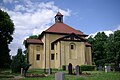
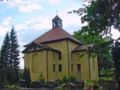
Category:Dorfkirche Lindenberg (Tauche)
Jump to navigation
Jump to search
| Object location | | View all coordinates using: OpenStreetMap |
|---|
This is the category of the Brandenburger Baudenkmal (cultural heritage monument) with the ID 09115279 (Wikidata)
|
church building in Oder-Spree district, Brandenburg state, Germany  | |||||
| Upload media | |||||
| Instance of | |||||
|---|---|---|---|---|---|
| Location | Lindenberg, Tauche, Oder-Spree District, Brandenburg, Germany | ||||
| Architectural style | |||||
| Heritage designation | |||||
 | |||||
Media in category "Dorfkirche Lindenberg (Tauche)"
The following 5 files are in this category, out of 5 total.
-
 Kirche Lindenberg (Tauche) 07-08-2016.JPG 2,736 × 3,648; 3.41 MB
-
 Kirche Lindenberg Tauche.jpg 3,872 × 2,592; 1,001 KB
-
 Lindenberg kirche.jpg 1,600 × 1,200; 1.13 MB
-
 Lindenberger Kirche (Tauche) 2016-08-07.JPG 3,648 × 2,048; 2.62 MB
-
 LOS 08-13 img07 Lindenberg.jpg 3,200 × 3,200; 4.53 MB
_07-08-2016.JPG)


_2016-08-07.JPG)