Category:Dorfkirche Lohm
Jump to navigation
Jump to search
| Object location | | View all coordinates using: OpenStreetMap |
|---|
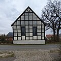
church building in Ostprignitz-Ruppin district, Brandenburg state, Germany  | |||||
| Upload media | |||||
| Instance of | |||||
|---|---|---|---|---|---|
| Location | Lohm, Zernitz-Lohm, Ostprignitz-Ruppin District, Brandenburg, Germany | ||||
| Street address |
| ||||
| Heritage designation | |||||
| Inception |
| ||||
| Religion or worldview | |||||
 | |||||
This is the category of the Brandenburger Baudenkmal (cultural heritage monument) with the ID 09170627 (Wikidata)
|
English: Church in Lohm, Zernitz-Lohm municipality, Ostprignitz-Ruppin district, Brandenburg state, Germany
Deutsch: Dorfkirche in Lohm, Stadt Zernitz-Lohm, Landkreis Ostprignitz-Ruppin, Land Brandenburg, Deutschland.
Français : Église de Lohm, commune de Zernitz-Lohm, arrondissement Prignitz-de-l'Est-Ruppin, état fédéral de Brandebourg, Allemagne
Pages in category "Dorfkirche Lohm"
This category contains only the following page.
Media in category "Dorfkirche Lohm"
The following 11 files are in this category, out of 11 total.
-
 Dorfkirche Lohm 2024 ENE.jpg 2,985 × 2,985; 1.72 MB
-
 Dorfkirche Lohm 2024 Fenster.jpg 2,736 × 3,648; 3.39 MB
-
 Dorfkirche Lohm 2024 NNE.jpg 2,774 × 2,219; 1.29 MB
-
 Dorfkirche Lohm 2024 NW.jpg 3,648 × 2,736; 3.6 MB
-
 Dorfkirche Lohm 2024 Portal.jpg 2,617 × 3,490; 1.37 MB
-
 Dorfkirche Lohm 2024 SE.jpg 4,032 × 3,024; 4.59 MB
-
 Dorfkirche Lohm 2024 SSE.jpg 3,648 × 2,736; 3.35 MB
-
 Dorfkirche Lohm 2024 Turm.jpg 3,648 × 2,736; 3.48 MB
-
 Lohm church 2016 NNW.jpg 6,741 × 3,077; 7.66 MB
-
 Lohm church 2016 NW.JPG 4,864 × 3,648; 6.61 MB
-
 Lohm church 2016 SSE.JPG 4,864 × 3,648; 4.51 MB


