Category:Dorfkirche Prießen
Jump to navigation
Jump to search
| Object location | | View all coordinates using: OpenStreetMap |
|---|
church building in Brandenburg state, Germany  .jpg) | |||||
| Upload media | |||||
| Instance of | |||||
|---|---|---|---|---|---|
| Location | Prießen, Doberlug-Kirchhain, Elbe-Elster District, Brandenburg, Germany | ||||
| Street address |
| ||||
| Heritage designation | |||||
| Inception |
| ||||
| Religion or worldview | |||||
 | |||||
This is the category of the Brandenburger Baudenkmal (cultural heritage monument) with the ID 09135072 (Wikidata)
|
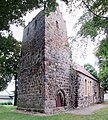
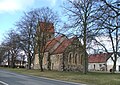
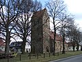
Deutsch: Die evangelische Dorfkirche in Prießen, Mark Brandenburg, gehört und dient einer Gemeinde der unierten Evangelischen Kirche Berlin-Brandenburg-Schlesische Oberlausitz.
English: The Village Church in Prießen, a locality of Doberlug-Kirchhain, Brandenburg, Germany, is owned and used by a congregation within the Evangelical Church of Berlin-Brandenburg-Silesian Upper Lusatia, a united Protestant church body of Calvinist, Lutheran and united congregations.
Media in category "Dorfkirche Prießen"
The following 7 files are in this category, out of 7 total.
-
 Kirche zu Prießen Winter.JPG 1,984 × 1,488; 1.83 MB
-
 Priessen Kirche.jpg 4,251 × 4,743; 1.24 MB
-
 Prießen, Dorfkirche (01).jpg 3,802 × 2,848; 1.85 MB
-
 Prießen, Dorfkirche (02).jpg 1,923 × 2,145; 703 KB
-
 Prießen Kirche 2.JPG 2,212 × 1,563; 746 KB
-
 Prießen Kirche 2b.jpg 1,290 × 1,116; 1.41 MB
-
 Prießen Kirche.JPG 2,272 × 1,704; 1.95 MB


.jpg)

