Category:Dorfkirche Röpersdorf
Jump to navigation
Jump to search
| Object location | | View all coordinates using: OpenStreetMap |
|---|
church building in Brandenburg state, Germany  ,_Dorfkirche_(10).jpg) | |||||
| Upload media | |||||
| Instance of | |||||
|---|---|---|---|---|---|
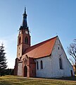
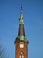
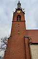
| Location | Röpersdorf, Nordwestuckermark, Uckermark District, Brandenburg, Germany | ||||
| Street address |
| ||||
| Has part(s) | |||||
| Heritage designation | |||||
 | |||||
This is the category of the Brandenburger Baudenkmal (cultural heritage monument) with the ID 09130152 (Wikidata)
|
English: Church in Röpersdorf, Nordwestuckermark municipality, Uckermark district, Brandenburg state, Germany
Deutsch: Kirche in Röpersdorf, Gemeinde Nordwestuckermark, Landkreis Uckermark, Land Brandenburg, Deutschland.
Français : Église de Röpersdorf, commune de Nordwestuckermark, arrondissement Uckermark, état fédéral de Brandebourg, Allemagne
Subcategories
This category has only the following subcategory.
I
Pages in category "Dorfkirche Röpersdorf"
This category contains only the following page.
Media in category "Dorfkirche Röpersdorf"
The following 22 files are in this category, out of 22 total.
-
 Dorfkirche Röpersdorf 2018 E.jpg 3,648 × 4,864; 4.72 MB
-
 Dorfkirche Röpersdorf 2018 Friedhofstor.jpg 3,648 × 4,864; 3.54 MB
-
 Dorfkirche Röpersdorf 2018 Infotafel.jpg 4,864 × 3,648; 3.67 MB
-
 Dorfkirche Röpersdorf 2018 N Panorama.jpg 4,808 × 3,572; 5.72 MB
-
 Dorfkirche Röpersdorf 2018 NW Panorama.jpg 4,864 × 3,648; 6.02 MB
-
 Dorfkirche Röpersdorf 2018 NW.jpg 3,648 × 4,864; 5 MB
-
 Dorfkirche Röpersdorf 2018 SE.jpg 4,175 × 4,644; 6.27 MB
-
 Dorfkirche Röpersdorf 2018 Südportal.jpg 3,648 × 4,864; 6.95 MB
-
 Dorfkirche Röpersdorf 2018 Turm NW.jpg 3,648 × 4,864; 5.98 MB
-
 Dorfkirche Röpersdorf 2018 Turmhelm.jpg 3,564 × 4,802; 4.42 MB
-
 Dorfkirche Röpersdorf 2018 W.jpg 3,598 × 4,826; 5.8 MB
-
 Dorfkirche Röpersdorf 2018 Westportal.jpg 3,358 × 4,526; 6.74 MB
-
 Dorfkirche Röpersdorf 2018 WNW.jpg 3,648 × 4,864; 5.07 MB
-
 Dorfkirche Röpersdorf 2018 WSW.jpg 3,648 × 4,864; 5.3 MB
-
 2017-07-24 Röpersdorf (Uckermark), Kirche (freddy2001).jpg 3,268 × 4,902; 10.84 MB
-
 Röpersdorf (Nordwestuckermark), Dorfkirche (1).jpg 2,721 × 3,261; 1.99 MB
-
 Röpersdorf (Nordwestuckermark), Dorfkirche (13).jpg 3,934 × 2,951; 4.03 MB
-
 Röpersdorf (Nordwestuckermark), Dorfkirche (14).jpg 2,605 × 3,224; 1.54 MB
-
 Röpersdorf (Nordwestuckermark), Dorfkirche (2).jpg 2,141 × 2,863; 2.11 MB
-
 Röpersdorf (Nordwestuckermark), Dorfkirche (3).jpg 2,541 × 3,913; 4.25 MB
-
 Röpersdorf (Nordwestuckermark), Dorfkirche (4).jpg 2,924 × 4,000; 5.44 MB
-
 RöpersdorfDorfkirche.jpg 2,460 × 1,002; 1.74 MB


,_Kirche_(freddy2001).jpg)
,_Dorfkirche_(1).jpg)
,_Dorfkirche_(13).jpg)
,_Dorfkirche_(14).jpg)
,_Dorfkirche_(2).jpg)
,_Dorfkirche_(3).jpg)
,_Dorfkirche_(4).jpg)