Category:Dorfkirche Schönfeld (Perleberg)
Jump to navigation
Jump to search
| Object location | | View all coordinates using: OpenStreetMap |
|---|
 | |||||
| Upload media | |||||
| Instance of | |||||
|---|---|---|---|---|---|
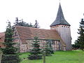
| Location | Schönfeld, Perleberg, Prignitz District, Brandenburg, Germany | ||||
| Heritage designation | |||||
 | |||||
This is the category of the Brandenburger Baudenkmal (cultural heritage monument) with the ID 09160437 (Wikidata)
|
Français : Église de Schönfeld, ville de Perleberg, arrondissement Prignitz, état fédéral de Brandebourg, Allemagne
Media in category "Dorfkirche Schönfeld (Perleberg)"
The following 5 files are in this category, out of 5 total.
-
 Kirche schönfeld 1.jpg 4,000 × 3,000; 4.31 MB
-
 Kirche schönfeld 3.jpg 3,000 × 4,000; 4.18 MB
-
 Kirche schönfeld 4.jpg 3,000 × 4,000; 4.09 MB
-
 Kirche schönfeld 6.jpg 4,000 × 3,000; 4.54 MB
-
 Kirche schönfeld 7.jpg 4,000 × 3,000; 4.42 MB


