Category:Dorfkirche Schilda
Jump to navigation
Jump to search
| Object location | | View all coordinates using: OpenStreetMap |
|---|
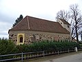
church building in Elbe-Elster district, Germany  | |||||
| Upload media | |||||
| Instance of | |||||
|---|---|---|---|---|---|
| Location | Schilda, Elbe-Elster District, Brandenburg, Germany | ||||
| Street address |
| ||||
| Architectural style |
| ||||
| Heritage designation | |||||
| Inception |
| ||||
| Religion or worldview | |||||
 | |||||
This is the category of the Brandenburger Baudenkmal (cultural heritage monument) with the ID 09135125 (Wikidata)
|
Media in category "Dorfkirche Schilda"
The following 15 files are in this category, out of 15 total.
-
 Schilda Kirche Ausschnitt.jpg 367 × 511; 42 KB
-
 Schilda Kirche.jpg 1,821 × 1,308; 300 KB
-
 Schilda01658.JPG 3,888 × 5,184; 7.97 MB
-
 Schilda01659.JPG 5,184 × 3,888; 5.85 MB
-
 Schilda01660.JPG 5,184 × 3,888; 5.91 MB
-
 Schilda01661.JPG 5,184 × 3,888; 6.71 MB
-
 Schilda01662 Ausschnitt.jpg 3,684 × 2,906; 1.93 MB
-
 Schilda01662.JPG 5,184 × 3,888; 6.12 MB
-
 Schilda01663.JPG 3,888 × 5,184; 5.84 MB
-
 Schilda01664.JPG 3,888 × 5,184; 5.8 MB
-
 Schilda01665.JPG 3,888 × 5,184; 5.6 MB
-
 Schilda01666.JPG 5,184 × 3,888; 6.13 MB
-
 Schilda01668.JPG 5,184 × 3,888; 8.32 MB
-
 Schilda1657 Ausschnitt.jpg 3,888 × 2,829; 2.18 MB
-
 Schilda1657.JPG 3,888 × 5,184; 7.64 MB


