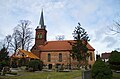
Category:Dorfkirche Schmerzke
Jump to navigation
Jump to search
| Object location | | View all coordinates using: OpenStreetMap |
|---|
 | |||||
| Upload media | |||||
| Instance of | |||||
|---|---|---|---|---|---|
| Location | Schmerzke, Brandenburg an der Havel, Brandenburg, Germany | ||||
| Heritage designation | |||||
 | |||||
This is the category of the Brandenburger Baudenkmal (cultural heritage monument) with the ID 09145741 (Wikidata)
|
Media in category "Dorfkirche Schmerzke"
The following 4 files are in this category, out of 4 total.
-
 Kirche Schmerzke Brandenburg Süden.jpg 4,928 × 3,264; 7.94 MB
-
 Kirche Schmerzke Brandenburg.jpg 4,928 × 3,264; 7.37 MB
-
 Kirche schmerzke nordost.jpg 3,027 × 2,273; 2.06 MB
-
 Kirche schmerzke nordwest.jpg 3,264 × 2,448; 2.07 MB


