Category:Dorfkirche Thomsdorf
Jump to navigation
Jump to search
| Object location | | View all coordinates using: OpenStreetMap |
|---|
church building in Brandenburg state, Germany  | |||||
| Upload media | |||||
| Instance of | |||||
|---|---|---|---|---|---|
| Location | Thomsdorf, Boitzenburger Land, Uckermark District, Brandenburg, Germany | ||||
| Heritage designation | |||||
 | |||||
This is the category of the Brandenburger Baudenkmal (cultural heritage monument) with the ID 09130437 (Wikidata)
|
English: Church in Thomsdorf, Boitzenburger Land municipality, Uckermark district, Brandenburg state, Germany
Deutsch: Kirche in Thomsdorf, Gemeinde Boitzenburger Land, Landkreis Uckermark, Land Brandenburg, Deutschland.
Français : Église de Thomsdorf, commune de Boitzenburger Land, arrondissement Uckermark, état fédéral de Brandebourg, Allemagne
Media in category "Dorfkirche Thomsdorf"
The following 4 files are in this category, out of 4 total.
-
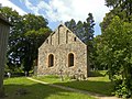
 Dorfkirche Thomsdorf.jpg 3,648 × 2,736; 4.75 MB
-
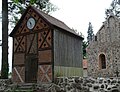 Glockenhaus vor Dorfkirche Thomsdorf.jpg 1,946 × 1,484; 962 KB
-
 Thomsdorf Glockenturm.jpg 3,648 × 2,736; 5.36 MB
-
 Thomsdorf, Dorfkirche.jpg 2,048 × 1,536; 1.52 MB


