Category:Dungeon bridge
Jump to navigation
Jump to search
| Object location | | View all coordinates using: OpenStreetMap |
|---|
bridge | |||||
| Upload media | |||||
| Instance of | |||||
|---|---|---|---|---|---|
| Location |
| ||||
 | |||||
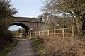
Single arch bridge in blue brick over the Wirral Way near Thurstaston visitor centre. Old maps strongly suggest this was an occupation bridge giving access to fields associated with Hall Farm, and it is in use as a farm track.
Media in category "Dungeon bridge"
The following 9 files are in this category, out of 9 total.
-
 Bridge on the Wirral Way - geograph.org.uk - 376090.jpg 640 × 457; 85 KB
-
 Bridge over the Wirral Way path - geograph.org.uk - 1737049.jpg 800 × 530; 221 KB
-
 Dungeon Bridge 1.jpg 5,096 × 3,300; 10.42 MB
-
 Dungeon Bridge 2.jpg 4,948 × 3,220; 9.79 MB
-
 Dungeon Bridge 3.jpg 5,184 × 3,456; 9.84 MB
-
 Dungeon Bridge 4.jpg 5,184 × 3,456; 9.63 MB
-
 Dungeon Bridge 5.jpg 5,184 × 3,456; 10.36 MB
-
 Dungeon Bridge 6.jpg 4,948 × 3,084; 10.17 MB
-
 Dungeon Bridge sign.jpg 4,940 × 3,276; 8.31 MB


