Category:Dutch Guiana, with plan and map (1876) by William G. Palmgrave
Jump to navigation
Jump to search
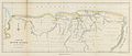
English: Dutch Guiana, with plan and map... (1876)
| This category includes images from a book scanned for the British Library Mechanical Curator collection.
The full set of images from the book is available on Flickr. |
Media in category "Dutch Guiana, with plan and map (1876) by William G. Palmgrave"
The following 3 files are in this category, out of 3 total.
-
 PALGRAVE1876 Dutch Guiana.png 497 × 724; 198 KB
-
 1876 Map of Suriname.jpg 4,842 × 2,065; 4.1 MB
-
 Plan von Paramaribo.jpg 3,107 × 2,235; 3.63 MB


