Category:Eday
Jump to navigation
Jump to search

island of the Orkney islands, Scotland, UK   | |||||
| Upload media | |||||
| Instance of | |||||
|---|---|---|---|---|---|
| Part of | |||||
| Location |
| ||||
| Located in or next to body of water | |||||
| Width |
| ||||
| Length |
| ||||
| Population |
| ||||
| Area |
| ||||
 | |||||
Subcategories
This category has the following 15 subcategories, out of 15 total.
- Farms in Eday (5 F)
B
- B9063 road (Scotland) (4 F)
- Backaland (14 F)
- Braeside cairn (3 F)
C
- Calf Sound, Orkney Islands (2 F)
E
- Eday Airport (2 F)
H
- Huntersquoy (2 F)
L
- Loch London (1 F)
M
- Mill Loch, Eday (2 F)
- Millbounds (1 F)
S
- Southside, Orkney Islands (1 F)
- Stone of Setter (5 F)
V
- Veness (hamlet) (1 F)
Media in category "Eday"
The following 200 files are in this category, out of 249 total.
(previous page) (next page)-
 Abandoned croft - geograph.org.uk - 1310547.jpg 640 × 425; 69 KB
-
 Approaching Dyke End, Eday - geograph.org.uk - 1267408.jpg 640 × 430; 105 KB
-
 Approaching Eday Pier - geograph.org.uk - 4540703.jpg 640 × 480; 403 KB
-
 Approaching Eday Pier - geograph.org.uk - 4540704.jpg 640 × 480; 404 KB
-
 Axna Geo, Fers Ness, Eday - geograph.org.uk - 1885236.jpg 640 × 427; 53 KB
-
 B9063 - geograph.org.uk - 232265.jpg 640 × 484; 64 KB
-
 Backaland, Eday - geograph.org.uk - 1291181.jpg 640 × 425; 69 KB
-
 Baxter's Patent Knapping Motion - geograph.org.uk - 1292530.jpg 640 × 425; 97 KB
-
 Bay of Doomy - geograph.org.uk - 1245327.jpg 640 × 425; 85 KB
-
 Bay of London, Eday. - geograph.org.uk - 531444.jpg 640 × 426; 82 KB
-

-
 Boardwalk over bog - geograph.org.uk - 1299374.jpg 640 × 444; 92 KB
-
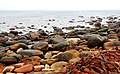
 Boulder Beach - geograph.org.uk - 1245261.jpg 640 × 425; 92 KB
-
 Boulder Beach - geograph.org.uk - 1277272.jpg 640 × 470; 114 KB
-
 Boulder beach near Broad Ebb - geograph.org.uk - 1245272.jpg 640 × 394; 95 KB
-
 Boulder clay - geograph.org.uk - 1279110.jpg 640 × 430; 99 KB
-
 Calfsound from Eday - geograph.org.uk - 6681135.jpg 1,600 × 1,200; 314 KB
-
 Carrick House, Eday - geograph.org.uk - 2123785.jpg 640 × 480; 83 KB
-
 Chambered cairn - geograph.org.uk - 1299380.jpg 640 × 425; 114 KB
-
 Cliffs near Higha Clett - geograph.org.uk - 1267445.jpg 414 × 640; 92 KB
-
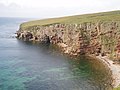 Cliffs on Eday - geograph.org.uk - 882448.jpg 640 × 480; 89 KB
-
 Cliffs on Eday - geograph.org.uk - 882450.jpg 640 × 480; 109 KB
-
 Cliffs on the west coast of Eday - geograph.org.uk - 6320688.jpg 6,000 × 4,000; 6.88 MB
-
 Clifftop dyke and stile - geograph.org.uk - 1279068.jpg 640 × 437; 132 KB
-
 Coastal erosion - geograph.org.uk - 1267505.jpg 640 × 443; 125 KB
-
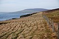 Coastal fence - geograph.org.uk - 1267503.jpg 640 × 425; 83 KB
-
 Coastal moorland - geograph.org.uk - 1289246.jpg 640 × 426; 101 KB
-
 Coastal View Near Southside, Eday - geograph.org.uk - 4088992.jpg 2,560 × 1,920; 2.55 MB
-
 Coastal View Towards War Ness - geograph.org.uk - 4089017.jpg 2,560 × 1,920; 2.8 MB
-
 Coastline at Greenan Nev - geograph.org.uk - 1245255.jpg 640 × 425; 96 KB
-
 Coastline at Greenan Nev - geograph.org.uk - 1274444.jpg 640 × 413; 111 KB
-
 Coastline at Stackie Geos - geograph.org.uk - 1310542.jpg 640 × 425; 58 KB
-
 Community Building, Eday - geograph.org.uk - 1299232.jpg 640 × 425; 75 KB
-
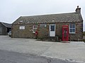 Community Shop and Phone Box, Eday - geograph.org.uk - 2123830.jpg 640 × 480; 55 KB
-
 Cooperhall, Eday - geograph.org.uk - 1291184.jpg 640 × 425; 78 KB
-

-
 Cottage by the shore - geograph.org.uk - 1290947.jpg 640 × 404; 61 KB
-
 Cottage on the coast - geograph.org.uk - 1245361.jpg 640 × 425; 64 KB
-
 Cove in the wave-cut platform - geograph.org.uk - 1279013.jpg 640 × 400; 109 KB
-
 Derelict buildings - geograph.org.uk - 1289254.jpg 640 × 425; 63 KB
-
 Derelict buildings, Stackie Geos - geograph.org.uk - 1310534.jpg 640 × 425; 46 KB
-
 Derelict croft - geograph.org.uk - 1274425.jpg 640 × 405; 80 KB
-
 Derelict crofthouse - geograph.org.uk - 1267511.jpg 640 × 425; 90 KB
-
 Disused Quarry - geograph.org.uk - 1245367.jpg 640 × 425; 80 KB
-
 Disused Quarry - geograph.org.uk - 1292542.jpg 640 × 425; 85 KB
-
 Drain and farmland - geograph.org.uk - 1291176.jpg 640 × 425; 93 KB
-
 Drain and rough grazing - geograph.org.uk - 1290949.jpg 640 × 491; 133 KB
-
 Drainage ditch - geograph.org.uk - 1279074.jpg 640 × 417; 117 KB
-
 Dry gully, Eday - geograph.org.uk - 1274421.jpg 640 × 425; 107 KB
-
 Dwelling near Greenan Nev - geograph.org.uk - 1274446.jpg 640 × 425; 102 KB
-
 Dyke and farmland - geograph.org.uk - 1299225.jpg 640 × 439; 77 KB
-
 Dyke and fence - geograph.org.uk - 1278990.jpg 640 × 406; 102 KB
-
 Dyke and pasture - geograph.org.uk - 1299226.jpg 640 × 444; 71 KB
-
 Dyke End - geograph.org.uk - 1245233.jpg 640 × 425; 108 KB
-
 Dyke with lichens - geograph.org.uk - 1278983.jpg 640 × 425; 90 KB
-

-
 Eday - geograph.org.uk - 3492729.jpg 640 × 480; 44 KB
-
 Eday - geograph.org.uk - 3492820.jpg 640 × 480; 40 KB
-
 Eday - Heading towards Calf of Eday Lighthouse - geograph.org.uk - 3744797.jpg 1,024 × 768; 180 KB
-
 Eday - Old Red Sandstone - geograph.org.uk - 496499.jpg 640 × 425; 72 KB
-

-
 Eday EMEC site.jpg 635 × 473; 163 KB
-
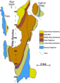 Eday geology.png 744 × 1,022; 133 KB
-
 Eday Gruna buoy - geograph.org.uk - 5117066.jpg 1,000 × 669; 566 KB
-
 Eday London Airport - geograph.org.uk - 2059071.jpg 1,697 × 1,177; 310 KB
-
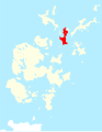 Eday Orkney.svg 1,110 × 1,424; 731 KB
-
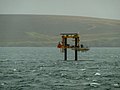 Eday Tidal Generator - geograph.org.uk - 3492831.jpg 640 × 480; 62 KB
-

-
 Eday Youth Hostel 1992 - geograph.org.uk - 2986094.jpg 800 × 532; 111 KB
-

-

-
 Eday, Bay of London - geograph.org.uk - 6681143.jpg 1,600 × 1,200; 380 KB
-
 Eday, Black Grip reaches the sea - geograph.org.uk - 4709130.jpg 640 × 481; 111 KB
-
 Eday, Calf of Eday Lighthouse - geograph.org.uk - 3744803.jpg 1,024 × 768; 166 KB
-

-
 Eday, Cliffs at the N end of Red Head - geograph.org.uk - 3744812.jpg 1,024 × 768; 158 KB
-

-

-
 Eday, London Airport sign - geograph.org.uk - 3744849.jpg 1,024 × 768; 106 KB
-
-
 Eday, Mill Bay - geograph.org.uk - 4713599.jpg 640 × 480; 59 KB
-

-
 Eday, Path leading up to Red Head - geograph.org.uk - 3744805.jpg 1,024 × 768; 183 KB
-
 Eday, path to Red Head - geograph.org.uk - 4709139.jpg 640 × 481; 92 KB
-
 Eday, postbox № KW17 101 - geograph.org.uk - 4709108.jpg 480 × 640; 54 KB
-
 Eday, postbox № KW17 114 and phone - geograph.org.uk - 4709092.jpg 640 × 480; 97 KB
-
 Eday, postbox № KW17 89 and phone - geograph.org.uk - 4709101.jpg 640 × 480; 76 KB
-
 Eday, postbox № KW17 96 - geograph.org.uk - 4709078.jpg 480 × 640; 91 KB
-
 Eday, Sands of Doomy - geograph.org.uk - 4707696.jpg 640 × 480; 60 KB
-
 Eday, Sands of Mussetter - geograph.org.uk - 4707693.jpg 640 × 480; 57 KB
-

-
 Eday, Stephen's Gate, Natural Arch (View N) - geograph.org.uk - 3744787.jpg 1,024 × 768; 171 KB
-
 Eday, Stephen's Gate, Natural Arch (View S) - geograph.org.uk - 3744792.jpg 1,024 × 768; 180 KB
-
 Eday, Stone of Setter - geograph.org.uk - 3744835.jpg 768 × 1,024; 165 KB
-

-
 Eday, the B9063 heads for the pier - geograph.org.uk - 4707671.jpg 640 × 480; 57 KB
-

-
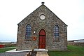
 Eday, the kirk - geograph.org.uk - 4709064.jpg 640 × 480; 56 KB
-
 Eday, the old course of the B9063 - geograph.org.uk - 4707641.jpg 640 × 480; 71 KB
-
 Eday, the old Faray postbox - geograph.org.uk - 4707660.jpg 480 × 640; 71 KB
-
 Eday, the old St. Mary’s church - geograph.org.uk - 4709070.jpg 640 × 480; 70 KB
-
 Eday, the Stone of Setter - geograph.org.uk - 4713595.jpg 480 × 640; 70 KB
-

-
 Eday, towards Calf Sound lighthouse - geograph.org.uk - 4713576.jpg 640 × 480; 80 KB
-

-
 Eday, Trig point at Red Head - geograph.org.uk - 3744810.jpg 1,024 × 768; 171 KB
-
 Eday, Trig point on Stennie Hill - geograph.org.uk - 3744846.jpg 1,024 × 768; 165 KB
-

-

-
 Eday, View across Calf Sound to Red Head - geograph.org.uk - 3744779.jpg 1,024 × 768; 149 KB
-
 Eday, view east along Calf Sound - geograph.org.uk - 4713586.jpg 640 × 480; 51 KB
-
 Eday, view N towards Whitemaw Bay - geograph.org.uk - 3744852.jpg 1,024 × 768; 153 KB
-
 Eday, Walking N along coast E of Hammerhill - geograph.org.uk - 3744784.jpg 1,024 × 768; 175 KB
-
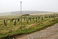
 Eday, Wooden directional post S of Ward Hill - geograph.org.uk - 3744872.jpg 768 × 1,024; 198 KB
-
 EdayMarl1.JPG 452 × 678; 72 KB
-
 Electric fence - geograph.org.uk - 1279088.jpg 640 × 437; 108 KB
-
 Electric fences and barbed wire - geograph.org.uk - 1245353.jpg 640 × 405; 113 KB
-
 Faray.jpg 500 × 375; 38 KB
-
 Farm buildings at Green - geograph.org.uk - 1245378.jpg 640 × 402; 49 KB
-
 Farm buildings at Green - geograph.org.uk - 4540701.jpg 640 × 480; 400 KB
-
 Farm buildings at Newark - geograph.org.uk - 1289242.jpg 640 × 425; 93 KB
-
 Ferry and the foreshore - geograph.org.uk - 1290952.jpg 640 × 431; 102 KB
-
 Ferry arriving, Eday pier - geograph.org.uk - 1385524.jpg 640 × 428; 47 KB
-
 Ferry through the mist - geograph.org.uk - 1310577.jpg 640 × 393; 28 KB
-
 Fers Ness - geograph.org.uk - 6320018.jpg 6,000 × 4,000; 5.54 MB
-
 Fersness - geograph.org.uk - 232302.jpg 640 × 480; 66 KB
-
 Fersness Hill - geograph.org.uk - 4088967.jpg 2,560 × 1,920; 2.55 MB
-
 Field of stubble - geograph.org.uk - 1292533.jpg 640 × 425; 96 KB
-
 Fishermans store, Eday - geograph.org.uk - 226911.jpg 640 × 491; 118 KB
-
 Flotsam near North Linkataing - geograph.org.uk - 1274529.jpg 640 × 396; 135 KB
-
 Fog in Calf Sound from Carrick House garden - geograph.org.uk - 3527873.jpg 1,600 × 1,067; 204 KB
-
 From Carrick House, out to sea, Eday - geograph.org.uk - 1385199.jpg 640 × 428; 65 KB
-
 From Eday towards Hoy - geograph.org.uk - 1728576.jpg 640 × 428; 39 KB
-

-
-
 Gate and fence - geograph.org.uk - 1267513.jpg 640 × 409; 76 KB
-
 Gated path near Dyke End, Eday - geograph.org.uk - 1267444.jpg 640 × 425; 85 KB
-
 Grazing sheep - geograph.org.uk - 1299221.jpg 640 × 434; 69 KB
-
 Green, Eday - geograph.org.uk - 5922490.jpg 1,024 × 576; 119 KB
-
 Greentoft, Eday - geograph.org.uk - 1245305.jpg 640 × 425; 98 KB
-
 Greenybrae Hill - geograph.org.uk - 4088836.jpg 2,560 × 1,920; 2.89 MB
-
 Heath-Robinson Wangle-Dangle, Eday - geograph.org.uk - 1292501.jpg 640 × 479; 113 KB
-
 His and Hers^ Hot and Cold^ - geograph.org.uk - 1245385.jpg 640 × 424; 97 KB
-
 Holm of Papay, and Eday - geograph.org.uk - 1727518.jpg 640 × 428; 68 KB
-
 Inside the community building - geograph.org.uk - 1299369.jpg 640 × 425; 80 KB
-
 Inside the sea caves, Eday - geograph.org.uk - 1385192.jpg 428 × 640; 64 KB
-
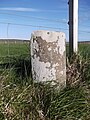
 Island milestone - geograph.org.uk - 6520775.jpg 1,200 × 1,600; 566 KB
-
 Island milestone - geograph.org.uk - 6520804.jpg 1,600 × 1,200; 469 KB
-
 Lane past Cooperhall - geograph.org.uk - 1291213.jpg 640 × 450; 82 KB
-
 Lane past Costyhead - geograph.org.uk - 1291226.jpg 640 × 425; 66 KB
-
 Lane to Cooperhall - geograph.org.uk - 1310571.jpg 640 × 425; 79 KB
-
 Lane to Green - geograph.org.uk - 1310567.jpg 640 × 370; 62 KB
-
 Lane to the ferry, Eday - geograph.org.uk - 1310559.jpg 640 × 402; 77 KB
-
 Loch of Carrick, Eday - geograph.org.uk - 2123775.jpg 640 × 480; 71 KB
-
 London Airport, Eday 2007 - geograph.org.uk - 3149426.jpg 640 × 427; 63 KB
-
 London airport, Eday, 2007, aerial - geograph.org.uk - 3149409.jpg 640 × 427; 62 KB
-
 Looking southwards to Southside - geograph.org.uk - 1291222.jpg 640 × 415; 66 KB
-
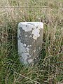 Milestone, Eday - geograph.org.uk - 2123803.jpg 480 × 640; 135 KB
-
 Milestone, Eday - geograph.org.uk - 2123808.jpg 640 × 480; 111 KB
-
 Mill Bay, Eday - geograph.org.uk - 2123833.jpg 640 × 480; 70 KB
-
 Moorland below Vinquoy Hill - geograph.org.uk - 1299390.jpg 640 × 425; 89 KB
-
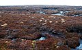 Moorland on Chapel Hill - geograph.org.uk - 1278781.jpg 640 × 395; 105 KB
-
 Near Chapel Hill - geograph.org.uk - 1278774.jpg 640 × 383; 90 KB
-
 Near North Farahouse, Eday - geograph.org.uk - 1245346.jpg 640 × 407; 83 KB
-
 Near Rushacloust - geograph.org.uk - 1245240.jpg 640 × 425; 76 KB
-
 Near the Clump of Blackber - geograph.org.uk - 1245229.jpg 640 × 418; 107 KB
-
 North Farahouse, Eday - geograph.org.uk - 1279082.jpg 640 × 392; 68 KB
-
 North Linkataing, Eday - geograph.org.uk - 1290883.jpg 640 × 425; 78 KB
-
 Nursery, Eday - geograph.org.uk - 1289250.jpg 640 × 439; 90 KB
-
 Offloading at Eday Pier - geograph.org.uk - 4540705.jpg 480 × 640; 379 KB
-
 Old croft, Eday - geograph.org.uk - 1310538.jpg 640 × 425; 62 KB
-
 Old dyke near Whitemaw Bay - geograph.org.uk - 1267501.jpg 640 × 426; 112 KB
-
 Old Milestone by the B9063, Eday parish - geograph.org.uk - 6055962.jpg 600 × 450; 241 KB
-
 Old Milestone by the B9063, Eday parish - geograph.org.uk - 6098062.jpg 450 × 600; 282 KB
-

-
 Ordnance Survey One-Inch Sheet 6 Orkney (Kirkwall), Published 1959.jpg 8,275 × 9,882; 8.34 MB
-
 Ork Eday.jpg 1,177 × 1,454; 124 KB
-
 Part of Seal Skerry - geograph.org.uk - 6320697.jpg 6,000 × 4,000; 3.22 MB
-
 Plantation on Vinquoy Hill, Eday - geograph.org.uk - 2123816.jpg 640 × 480; 63 KB
-
 Pumping station - geograph.org.uk - 1245250.jpg 640 × 444; 94 KB
-
 Rammy Geo, Eday - geograph.org.uk - 3492747.jpg 640 × 480; 46 KB
-
 Rammy Geo, Fers Ness, Eday - geograph.org.uk - 1885263.jpg 640 × 427; 73 KB
-
 Red Head - geograph.org.uk - 4088822.jpg 2,548 × 1,904; 1.92 MB
-
 Red Head on Eday lives up to its name. - geograph.org.uk - 530459.jpg 640 × 426; 105 KB
-
 Remains of chambered cairn - geograph.org.uk - 1299384.jpg 640 × 447; 107 KB
-
 Remains of chambered cairn - geograph.org.uk - 1299387.jpg 640 × 407; 91 KB
-
 Roadside drain - geograph.org.uk - 1292537.jpg 640 × 430; 93 KB
-
 Rocks off Red Head - geograph.org.uk - 231827.jpg 640 × 480; 79 KB
-
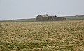
 Ruined Farmstead On Eday - geograph.org.uk - 4088975.jpg 2,560 × 1,920; 2.36 MB
-
 SE tip of Eday - geograph.org.uk - 1310551.jpg 640 × 425; 71 KB
-

-
 Seal Skerry - geograph.org.uk - 3492828.jpg 640 × 480; 42 KB
-
 Seal Skerry - geograph.org.uk - 6320705.jpg 6,000 × 4,000; 2.95 MB
-
 Seal Skerry, West coast of Eday - geograph.org.uk - 1885310.jpg 640 × 427; 61 KB
-
 Shoreline below West Side, Eday - geograph.org.uk - 1885275.jpg 640 × 427; 67 KB
-

-
 Soft going - geograph.org.uk - 1245322.jpg 640 × 420; 103 KB
-
 South Farahouse - geograph.org.uk - 1279024.jpg 640 × 381; 82 KB
-
 Standing stone near former quarry - geograph.org.uk - 4089005.jpg 2,560 × 1,920; 2.43 MB
-
 Stennie Hill - geograph.org.uk - 4088843.jpg 2,560 × 1,920; 2.69 MB


_-_geograph.org.uk_-_3744787.jpg)
_-_geograph.org.uk_-_3744792.jpg)


_-_geograph.org.uk_-_1385244.jpg)


,_Published_1959.jpg)


